Bestand:USA territorial growth.gif

Grootte van deze voorvertoning: 800 × 498 pixels. Andere resoluties: 320 × 199 pixels | 640 × 398 pixels | 921 × 573 pixels.
Oorspronkelijk bestand (921 × 573 pixels, bestandsgrootte: 2,01 MB, MIME-type: image/gif, herhalend, 10 frames, 50 s)
| Dit is een bestand van Wikimedia Commons. Onderstaande beschrijving komt van de beschrijving van het bestand daar. |
Beschrijving
| Beschrijving |
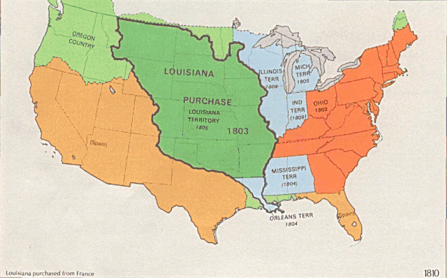
English: US territorial growth 1810–1920, based on the PD USGS maps in Category:Territorial growth maps of the United States.
See key below for explanation of colors.  |
||||||
| Bron |
|
||||||
| Auteur |
|
||||||
| Andere versies |
|

Licentie
Deze afbeelding bevindt zich in het publiek domein omdat het materiaal bevat dat oorspronkelijk afkomstig is van de United States Geological Survey, een agentschap van de United States Department of the Interior. Voor meer informatie, zie het officiële USGS-auteursrechtenbeleid
|
Bestandsgeschiedenis
Klik op een datum/tijd om het bestand te zien zoals het destijds was.
| Datum/tijd | Miniatuur | Afmetingen | Gebruiker | Opmerking | |
|---|---|---|---|---|---|
| huidige versie | 31 mei 2006 03:39 | | 921 × 573 (2,01 MB) | Roke~commonswiki | longer interval, 3 seconds --> 5 seconds |
| 30 mei 2006 14:21 |  | 921 × 573 (2,67 MB) | Roke~commonswiki | US territorial growth 1810-1920, based on the USGS maps in commons:Category:USA Territorial Growth Maps, put together in Corel Painter IX. The individual maps have this licence: {{PD-USGov-USGS}} If it is necessary for me to licence my contributio |
Bestandsgebruik
Dit bestand wordt op de volgende pagina gebruikt:
Globaal bestandsgebruik
De volgende andere wiki's gebruiken dit bestand:
- Gebruikt op bn.wikipedia.org
- Gebruikt op en.wikipedia.org
- Gebruikt op es.wikipedia.org
- Gebruikt op fa.wikipedia.org
- Gebruikt op fy.wikipedia.org
- Gebruikt op ha.wikipedia.org
- Gebruikt op he.wikipedia.org
- Gebruikt op pnb.wikipedia.org
- Gebruikt op ru.wikipedia.org
- Gebruikt op ru.wikinews.org
- Gebruikt op sr.wikipedia.org
- Gebruikt op tr.wikipedia.org
- Gebruikt op ur.wikipedia.org
- Gebruikt op uz.wikipedia.org
- Gebruikt op www.wikidata.org