Bestand:TTPI-locatormap.png
Geen hogere resolutie beschikbaar.
TTPI-locatormap.png (326 × 225 pixels, bestandsgrootte: 11 kB, MIME-type: image/png)
| Dit is een bestand van Wikimedia Commons. Onderstaande beschrijving komt van de beschrijving van het bestand daar. |

|
Deze kaartafbeelding zou opnieuw moeten worden aangemaakt als een SVG-bestand door vectorafbeeldingen te gebruiken. Dit heeft een aantal voordelen; zie Commons:Media for cleanup voor meer informatie. Als er een SVG-formaat van deze afbeelding bestaat, dan deze graag uploaden. Nadat u dit heeft gedaan, gelieve dit sjabloon te vervangen door het sjabloon {{vector version available|nieuwe bestandsnaam.svg}} op deze afbeeldingspagina.
|
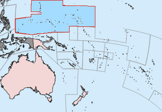
| Beschrijving |
Čeština: Mapa poručenského území Tichomořských ostrovů.
English: This is a locator map of the former Trust Territory of the Pacific Islands (TTPI). |
||||||||
| Bron | The map is based off of a locator map of Palau found on the German Wiki at de:Bild:Palau-Pos.png; it was created by German Wiki user de:Benutzer:Tzzzpfffand licensed under the GFDL. The changes made from the original map are various. The current boundries of the CNMI, Palau, FSM, and RMI are merged and Guam has it's own boundary due to the fact it never was a part of the TTPI. Boundries have been compared with Image:MapofTTPI.gif for accuracy. As the orginial image was licensed under the GFDL, I place my modification of the orginial map under the GFDL as well. | ||||||||
| Auteur |
|
||||||||
| Toestemming (Hergebruik van dit bestand) |
|


Bestandsgeschiedenis
Klik op een datum/tijd om het bestand te zien zoals het destijds was.
| Datum/tijd | Miniatuur | Afmetingen | Gebruiker | Opmerking | |
|---|---|---|---|---|---|
| huidige versie | 17 jun 2010 03:27 | | 326 × 225 (11 kB) | Ras67 | cropped |
| 19 nov 2006 16:52 |  | 330 × 228 (14 kB) | Electionworld | == Summary == This is a locator map of the former Trust Territory of the Pacific Islands (TTPI). The map is based off of a locator map of Palau found on the German Wiki at de:Bild:Palau-Pos.png; it was created by German Wiki user [[:de:Benutzer:T |
Bestandsgebruik
Dit bestand wordt op de volgende 4 pagina's gebruikt:
Globaal bestandsgebruik
De volgende andere wiki's gebruiken dit bestand:
- Gebruikt op ar.wikipedia.org
- Gebruikt op ast.wikipedia.org
- Gebruikt op azb.wikipedia.org
- Gebruikt op az.wikipedia.org
- Gebruikt op be.wikipedia.org
- Gebruikt op bg.wikipedia.org
- Gebruikt op ca.wikipedia.org
- Gebruikt op cs.wikipedia.org
- Gebruikt op da.wikipedia.org
- Gebruikt op de.wikipedia.org
- Gebruikt op en.wikipedia.org
- Trust Territory of the Pacific Islands
- Decolonization
- Japan–Oceania relations
- List of national border changes (1914–present)
- Aftermath of World War II
- High Commissioner of the Trust Territory of the Pacific Islands
- Wikipedia:Graphics Lab/Map workshop/Archive/Oct 2010
- Wikipedia:Reference desk/Archives/Humanities/2020 June 23
- Gebruikt op eo.wikipedia.org
- Gebruikt op es.wikipedia.org
- Gebruikt op fa.wikipedia.org
- Gebruikt op fi.wikipedia.org
- Gebruikt op fr.wikipedia.org
- Gebruikt op he.wikipedia.org
- Gebruikt op hu.wikipedia.org
- Gebruikt op hy.wikipedia.org
- Gebruikt op ia.wikipedia.org
- Gebruikt op id.wikipedia.org
- Gebruikt op it.wikipedia.org
- Gebruikt op ja.wikipedia.org
- Gebruikt op ko.wikipedia.org
- Gebruikt op lt.wikipedia.org
Globaal gebruik van dit bestand bekijken.