Bestand:St.Pölten Karte Stadtteile mit Beschriftung.svg

Afmetingen van deze voorvertoning van het type PNG van dit SVG-bestand: 506 × 600 pixels Andere resoluties: 202 × 240 pixels | 405 × 480 pixels | 648 × 768 pixels | 864 × 1.024 pixels | 1.727 × 2.048 pixels | 1.077 × 1.277 pixels.
Oorspronkelijk bestand (SVG-bestand, nominaal 1.077 × 1.277 pixels, bestandsgrootte: 65 kB)
| Dit is een bestand van Wikimedia Commons. Onderstaande beschrijving komt van de beschrijving van het bestand daar. |
| Beschrijving |
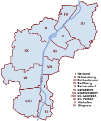
English: Map of St. Pölten
Deutsch: Karte von St. Pölten mit beschrifteten Stadtteilen. Die Zahlen sind Willkürlich nach dem Alphabet gewählt und haben keine offizielle Bedeutung |
| Datum | |
| Bron | Eigen werk |
| Auteur | AleXXw |
| Dit werk vrijgegeven in het publieke domein door de auteur, AleXXw. Dit is wereldwijd van toepassing. In sommige landen is dit wettelijk niet mogelijk; in die gevallen geldt: |
Bestandsgeschiedenis
Klik op een datum/tijd om het bestand te zien zoals het destijds was.
| Datum/tijd | Miniatuur | Afmetingen | Gebruiker | Opmerking | |
|---|---|---|---|---|---|
| huidige versie | 15 jan 2010 00:41 | | 1.077 × 1.277 (65 kB) | AleXXw | Pottenbrunn und Ratzersdorf vertauscht |
| 14 apr 2009 00:48 |  | 1.077 × 1.277 (88 kB) | AleXXw | Beschriftung in Legende | |
| 26 okt 2008 01:20 |  | 1.077 × 1.277 (37 kB) | AleXXw | {{Information |Description={{en|1=Map of St. Pölten, highlighting Harland}} {{de|1=Karte von St. Pölten mit dem hervorgehobenen Ortsteil Harland}} |Source=own work |Author=AleXXw |Date=2008-10-26 |Permission= |other_versions= }} {{PD-use |
Bestandsgebruik
Dit bestand wordt op de volgende pagina gebruikt:
Globaal bestandsgebruik
De volgende andere wiki's gebruiken dit bestand:
- Gebruikt op de.wikipedia.org
- Gebruikt op fy.wikipedia.org
- Gebruikt op sl.wikipedia.org
- Gebruikt op vep.wikipedia.org