Bestand:South Africa 2011 LGE council winners.svg

Afmetingen van deze voorvertoning van het type PNG van dit SVG-bestand: 684 × 599 pixels Andere resoluties: 274 × 240 pixels | 548 × 480 pixels | 876 × 768 pixels | 1.168 × 1.024 pixels | 2.337 × 2.048 pixels | 809 × 709 pixels.
Oorspronkelijk bestand (SVG-bestand, nominaal 809 × 709 pixels, bestandsgrootte: 1,67 MB)
| Dit is een bestand van Wikimedia Commons. Onderstaande beschrijving komt van de beschrijving van het bestand daar. |
Beschrijving
| Beschrijving |
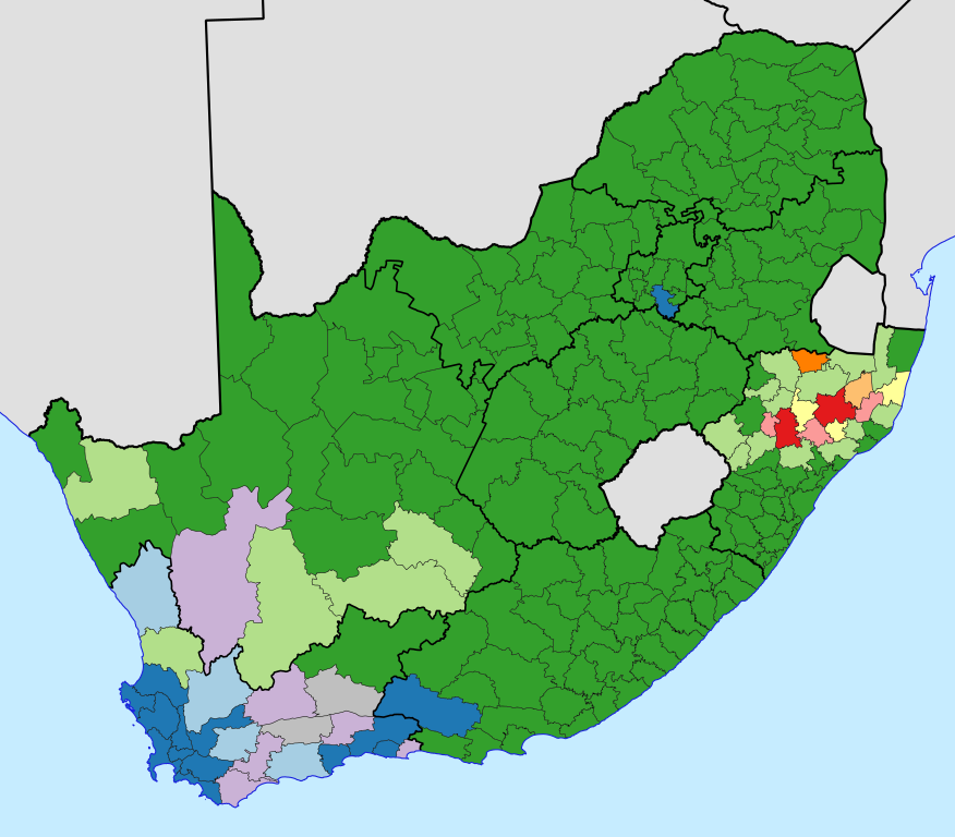
English: Map of South Africa, showing for each local and metropolitan municipality the state of the municipal council after the election of 18 May 2011.
African National Congress majority
No majority, ANC leading party
Democratic Alliance majority
No majority, DA leading party
Inkatha Freedom Party majority
No majority, IFP leading party
National Freedom Party majority
No majority, NFP leading party
No majority, another party leading
No majority, ANC-DA tie
No majority, ANC-IFP tie |
| Datum | |
| Bron | Eigen werk, based on File:Map of South Africa with municipal borders (2011).svg |
| Auteur | Htonl |
.svg)
Licentie
Ik, de auteursrechthebbende van dit werk, maak het hierbij onder de volgende licenties beschikbaar:

|
Toestemming wordt verleend voor het kopiëren, verspreiden en/of wijzigen van dit document onder de voorwaarden van de GNU-licentie voor vrije documentatie, versie 1.2 of enige latere versie als gepubliceerd door de Free Software Foundation; zonder Invariant Sections, zonder Front-Cover Texts, en zonder Back-Cover Texts. Een kopie van de licentie is opgenomen in de sectie GNU-licentie voor vrije documentatie. |
This file is licensed under the Creative Commons Attribution-Share Alike Attribution-Share Alike 4.0 International, 3.0 Unported, 2.5 Generic, 2.0 Generic and 1.0 Generic license.
- De gebruiker mag:
- Delen – het werk kopiëren, verspreiden en doorgeven
- Remixen – afgeleide werken maken
- Onder de volgende voorwaarden:
- naamsvermelding – U moet op een gepaste manier aan naamsvermelding doen, een link naar de licentie geven, en aangeven of er wijzigingen in het werk zijn aangebracht. U mag dit op elke redelijke manier doen, maar niet zodanig dat de indruk wordt gewekt dat de licentiegever instemt met uw werk of uw gebruik van zijn werk.
- Gelijk delen – Als u het werk heeft geremixt, veranderd, of erop heeft voortgebouwd, moet u het gewijzigde materiaal verspreiden onder dezelfde licentie als het oorspronkelijke werk, of een daarmee compatibele licentie.
U mag zelf één van de licenties kiezen.
Bestandsgeschiedenis
Klik op een datum/tijd om het bestand te zien zoals het destijds was.
| Datum/tijd | Miniatuur | Afmetingen | Gebruiker | Opmerking | |
|---|---|---|---|---|---|
| huidige versie | 8 jun 2011 01:40 | | 809 × 709 (1,67 MB) | Htonl | make district borders same width as other muni borders |
| 8 jun 2011 01:36 |  | 809 × 709 (1,67 MB) | Htonl | border width and colour | |
| 21 mei 2011 19:19 |  | 809 × 709 (1,67 MB) | Htonl | {{Information |Description ={{en|1=Map of South Africa, showing for each local and metropolitan municipality the state of the municipal council after the [[w:South A |
Bestandsgebruik
Dit bestand wordt op de volgende pagina gebruikt:
Globaal bestandsgebruik
De volgende andere wiki's gebruiken dit bestand:
- Gebruikt op af.wikipedia.org
- Gebruikt op en.wikipedia.org
- Gebruikt op fr.wikipedia.org