Bestand:SouthItaly 400BC map.svg

Afmetingen van deze voorvertoning van het type PNG van dit SVG-bestand: 570 × 599 pixels Andere resoluties: 228 × 240 pixels | 457 × 480 pixels | 731 × 768 pixels | 974 × 1.024 pixels | 1.948 × 2.048 pixels | 1.350 × 1.419 pixels.
Oorspronkelijk bestand (SVG-bestand, nominaal 1.350 × 1.419 pixels, bestandsgrootte: 2,09 MB)
| Dit is een bestand van Wikimedia Commons. Onderstaande beschrijving komt van de beschrijving van het bestand daar. |
Beschrijving
| Beschrijving |
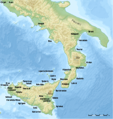
English: Map of South Italy (Grater Greece and Sicily) around 400 B.C. |
| Datum | |
| Bron | Eigen werk |
| Auteur | Uwe Dedering |
Licentie
Ik, de auteursrechthebbende van dit werk, maak het hierbij onder de volgende licentie beschikbaar:
Dit bestand is gelicenseerd onder de Creative Commons-licentie Naamsvermelding-Gelijk delen 3.0 Unported
- De gebruiker mag:
- Delen – het werk kopiëren, verspreiden en doorgeven
- Remixen – afgeleide werken maken
- Onder de volgende voorwaarden:
- naamsvermelding – U moet op een gepaste manier aan naamsvermelding doen, een link naar de licentie geven, en aangeven of er wijzigingen in het werk zijn aangebracht. U mag dit op elke redelijke manier doen, maar niet zodanig dat de indruk wordt gewekt dat de licentiegever instemt met uw werk of uw gebruik van zijn werk.
- Gelijk delen – Als u het werk heeft geremixt, veranderd, of erop heeft voortgebouwd, moet u het gewijzigde materiaal verspreiden onder dezelfde licentie als het oorspronkelijke werk, of een daarmee compatibele licentie.
Bestandsgeschiedenis
Klik op een datum/tijd om het bestand te zien zoals het destijds was.
| Datum/tijd | Miniatuur | Afmetingen | Gebruiker | Opmerking | |
|---|---|---|---|---|---|
| huidige versie | 11 okt 2010 11:08 | | 1.350 × 1.419 (2,09 MB) | Uwe Dedering | -himera |
| 30 sep 2010 16:11 |  | 1.350 × 1.419 (2,09 MB) | Uwe Dedering | Kale Acte | |
| 29 sep 2010 12:39 |  | 1.350 × 1.419 (2,09 MB) | Uwe Dedering | {{Information |Description={{en|1=Map of South Italy (Grater Greece and Sicily) around 400 B.C.}} |Source={{own}} |Author=Uwe Dedering |Date=2010-09-29 |Permission= |other_versions= }} Category:Maps of Italy |
Bestandsgebruik
Dit bestand wordt op de volgende 2 pagina's gebruikt:
Globaal bestandsgebruik
De volgende andere wiki's gebruiken dit bestand:
- Gebruikt op als.wikipedia.org
- Gebruikt op de.wikipedia.org
- Gebruikt op et.wikipedia.org
- Gebruikt op fr.wikipedia.org
- Gebruikt op hu.wikipedia.org
- Gebruikt op it.wikipedia.org
- Gebruikt op ru.wikipedia.org
- Gebruikt op uk.wikipedia.org