Bestand:Siberiariverroutemap.png

Grootte van deze voorvertoning: 800 × 477 pixels. Andere resoluties: 320 × 191 pixels | 640 × 381 pixels | 1.200 × 715 pixels.
Oorspronkelijk bestand (1.200 × 715 pixels, bestandsgrootte: 510 kB, MIME-type: image/png)
| Dit is een bestand van Wikimedia Commons. Onderstaande beschrijving komt van de beschrijving van het bestand daar. |
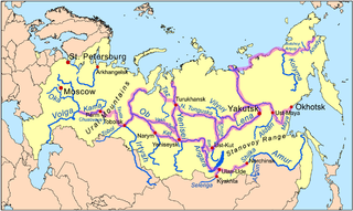
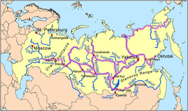
| Beschrijving | This is a map of the Siberian River Routes. | ||
| Datum | |||
| Bron | Own work using Digital Chart of the World data. Routes based on descriptions from Forsyth, James, "A History of the Peoples of Siberia",1992. | ||
| Auteur | Kmusser | ||
| Andere versies |
|

Ik, de auteursrechthebbende van dit werk, maak het hierbij onder de volgende licentie beschikbaar:
Dit bestand is gelicenseerd onder de Creative Commons-licentie Naamsvermelding-Gelijk delen 3.0 Unported
- De gebruiker mag:
- Delen – het werk kopiëren, verspreiden en doorgeven
- Remixen – afgeleide werken maken
- Onder de volgende voorwaarden:
- naamsvermelding – U moet op een gepaste manier aan naamsvermelding doen, een link naar de licentie geven, en aangeven of er wijzigingen in het werk zijn aangebracht. U mag dit op elke redelijke manier doen, maar niet zodanig dat de indruk wordt gewekt dat de licentiegever instemt met uw werk of uw gebruik van zijn werk.
- Gelijk delen – Als u het werk heeft geremixt, veranderd, of erop heeft voortgebouwd, moet u het gewijzigde materiaal verspreiden onder dezelfde licentie als het oorspronkelijke werk, of een daarmee compatibele licentie.
Bestandsgeschiedenis
Klik op een datum/tijd om het bestand te zien zoals het destijds was.
| Datum/tijd | Miniatuur | Afmetingen | Gebruiker | Opmerking | |
|---|---|---|---|---|---|
| huidige versie | 30 nov 2009 17:13 | | 1.200 × 715 (510 kB) | Kmusser | extend NE route, add Stanovoy label |
| 24 nov 2009 20:32 |  | 1.200 × 715 (503 kB) | Kmusser | Added route in far NE. | |
| 5 jan 2009 23:34 |  | 1.200 × 715 (492 kB) | Kmusser | corrections to Amur route | |
| 18 nov 2008 16:15 |  | 1.200 × 715 (490 kB) | Kmusser | added Ural label | |
| 17 nov 2008 23:57 |  | 1.000 × 596 (378 kB) | Kmusser | Expanded | |
| 12 nov 2008 22:34 |  | 800 × 477 (258 kB) | Kmusser | {{Information |Description=This is a map of the Siberian River Routes. |Source=Own work using http://www.maproom.psu.edu/dcw/ Digital Chart of the World data. |Date=November 12, 2008 |Author=Kmusser |Perm |
Bestandsgebruik
Dit bestand wordt op de volgende 4 pagina's gebruikt:
Globaal bestandsgebruik
De volgende andere wiki's gebruiken dit bestand:
- Gebruikt op ar.wikipedia.org
- Gebruikt op ca.wikipedia.org
- Gebruikt op cs.wikipedia.org
- Gebruikt op da.wikipedia.org
- Gebruikt op de.wikipedia.org
- Gebruikt op el.wikipedia.org
- Gebruikt op en.wikipedia.org
- Gebruikt op eo.wikipedia.org
- Gebruikt op es.wikipedia.org
- Gebruikt op fi.wikipedia.org
- Gebruikt op fr.wikipedia.org
- Gebruikt op he.wikipedia.org
- Gebruikt op hy.wikipedia.org
- Gebruikt op it.wikipedia.org
- Gebruikt op ja.wikipedia.org
- Gebruikt op ja.wikibooks.org
- Gebruikt op ko.wikipedia.org
- Gebruikt op mk.wikipedia.org
- Gebruikt op ru.wikipedia.org
- Gebruikt op sl.wikipedia.org
- Gebruikt op tr.wikipedia.org
- Gebruikt op uk.wikipedia.org
- Gebruikt op vi.wikipedia.org
- Gebruikt op zh.wikipedia.org
Globaal gebruik van dit bestand bekijken.