Bestand:Saint-Barthélemy collectivity relief location map.jpg

Grootte van deze voorvertoning: 800 × 526 pixels. Andere resoluties: 320 × 210 pixels | 640 × 420 pixels | 1.024 × 673 pixels | 1.175 × 772 pixels.
Oorspronkelijk bestand (1.175 × 772 pixels, bestandsgrootte: 172 kB, MIME-type: image/jpeg)
| Dit is een bestand van Wikimedia Commons. Onderstaande beschrijving komt van de beschrijving van het bestand daar. |
Beschrijving
| Cameralocatie | | Deze en andere afbeeldingen in: OpenStreetMap |
|---|
| Beschrijving |
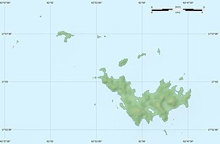
English: Blank physical map of the overseas collectivity of Saint Barthélemy, France, for geo-location purpose.
Français : Carte physique vierge de la collectivité d'outre-mer de Saint-Barthélemy, France, destinée à la géolocalisation. Scales: 1:372,000 (precision: 93 m) for the topography; 1:4,720,000 (precision: 1,180 m) for the bathymetry
Geographic limits of the map:
|
||
| Datum | |||
| Bron |
Eigen werk
|
||
| Auteur | Eric Gaba (Sting - fr:Sting) | ||
| Toestemming (Hergebruik van dit bestand) |
|
||
| Andere versies |
|


Licentie
Eric Gaba, Wikimedia Commons user Sting, de auteursrechthebbende van dit werk, maakt het hierbij onder de volgende licenties beschikbaar:
Dit bestand is gelicenseerd onder de Creative Commons-licentie Naamsvermelding-Gelijk delen 3.0 Unported
Naamsvermelding: Eric Gaba, Wikimedia Commons user Sting
- De gebruiker mag:
- Delen – het werk kopiëren, verspreiden en doorgeven
- Remixen – afgeleide werken maken
- Onder de volgende voorwaarden:
- naamsvermelding – U moet op een gepaste manier aan naamsvermelding doen, een link naar de licentie geven, en aangeven of er wijzigingen in het werk zijn aangebracht. U mag dit op elke redelijke manier doen, maar niet zodanig dat de indruk wordt gewekt dat de licentiegever instemt met uw werk of uw gebruik van zijn werk.
- Gelijk delen – Als u het werk heeft geremixt, veranderd, of erop heeft voortgebouwd, moet u het gewijzigde materiaal verspreiden onder dezelfde licentie als het oorspronkelijke werk, of een daarmee compatibele licentie.

|
Toestemming wordt verleend voor het kopiëren, verspreiden en/of wijzigen van dit document onder de voorwaarden van de GNU-licentie voor vrije documentatie, versie 1.2 of enige latere versie als gepubliceerd door de Free Software Foundation; zonder Invariant Sections, zonder Front-Cover Texts, en zonder Back-Cover Texts. Een kopie van de licentie is opgenomen in de sectie GNU-licentie voor vrije documentatie. |
U mag zelf één van de licenties kiezen.
Bestandsgeschiedenis
Klik op een datum/tijd om het bestand te zien zoals het destijds was.
| Datum/tijd | Miniatuur | Afmetingen | Gebruiker | Opmerking | |
|---|---|---|---|---|---|
| huidige versie | 18 jul 2010 23:14 | | 1.175 × 772 (172 kB) | Sting | Color profile |
| 26 feb 2010 03:39 |  | 1.175 × 772 (167 kB) | Sting | == {{int:filedesc}} == {{Location|17|55|30|N|62|51|45|W|scale:50000}} <br/> {{Information |Description={{en|Blank physical map of the overseas collectivity of Saint Barthélemy, France |
Bestandsgebruik
Dit bestand wordt op de volgende 6 pagina's gebruikt:
Globaal bestandsgebruik
De volgende andere wiki's gebruiken dit bestand:
- Gebruikt op ar.wikipedia.org
- Gebruikt op ast.wikipedia.org
- Gebruikt op bg.wikipedia.org
- Gebruikt op bs.wikipedia.org
- Gebruikt op ceb.wikipedia.org
- Gebruikt op ckb.wikipedia.org
- Gebruikt op da.wikipedia.org
- Gebruikt op de.wikipedia.org
- Gebruikt op en.wikipedia.org
- Gebruikt op eo.wikipedia.org
- Gebruikt op es.wikipedia.org
- Gebruikt op fa.wikipedia.org
- Gebruikt op fr.wikipedia.org
- Discussion utilisateur:Pethrus
- Gustavia (Saint-Barthélemy)
- Projet:Cartographie/Cartes standards/France
- Modèle:Géolocdual/Saint-Barthélemy
- Modèle:Géolocalisation/Saint-Barthélemy
- Wikipédia:Atelier graphique/Cartes/Archives/avril 2010
- Morne de Vitet
- Réserve naturelle nationale de Saint-Barthélemy Nicole-Aussedat
- Île Fourchue
- Île Chevreau
- Île Frégate (France)
- Île le Boulanger
- Île Coco
- Pain de Sucre (Saint-Barthélemy)
- Île Pelé
- Île Petit Jean
- Île Toc Vers
- La Tortue (Saint-Barthélemy)
- Liste des mammifères à Saint-Barthélemy
- Gebruikt op he.wikipedia.org
- Gebruikt op hr.wikipedia.org
Globaal gebruik van dit bestand bekijken.