Bestand:Recife-Map1665-ForteCincoPontas.jpg
Geen hogere resolutie beschikbaar.
Recife-Map1665-ForteCincoPontas.jpg (448 × 405 pixels, bestandsgrootte: 179 kB, MIME-type: image/jpeg)
| Dit is een bestand van Wikimedia Commons. Onderstaande beschrijving komt van de beschrijving van het bestand daar. |
Beschrijving
| Beschrijving |
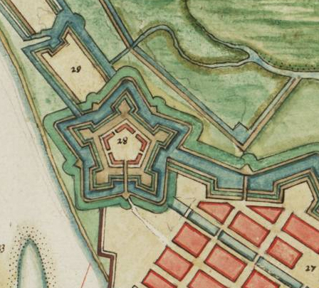
English: City of Recife (Brazil) in the 17th century showing the Fort of Cinco Pontas (labelled 28) |
||||
| Datum | |||||
| Bron | Vingboons Atlas (1665) | ||||
| Auteur | Onbekend | ||||
| Toestemming (Hergebruik van dit bestand) |
|
||||
Licentie
|
Het tweedimensionale kunstwerk afgebeeld op deze afbeelding valt in het publiek domein omdat:
Reproducties van het werk kunnen ook worden beschouwd als publiek domein omdat ze geen oorspronkelijk karakter hebben. Dit geldt voor reproducties gemaakt in de Verenigde Staten (zie Bridgeman Art Library v. Corel Corp.), Duitsland en veel andere landen.
| ||||
Bestandsgeschiedenis
Klik op een datum/tijd om het bestand te zien zoals het destijds was.
| Datum/tijd | Miniatuur | Afmetingen | Gebruiker | Opmerking | |
|---|---|---|---|---|---|
| huidige versie | 28 sep 2023 19:06 | | 448 × 405 (179 kB) | Beao | Cropped 2 % horizontally, 12 % vertically using CropTool with lossless mode. Removed watermark. |
| 28 sep 2008 23:18 |  | 458 × 459 (189 kB) | Fulviusbsas | {{Information |Description={{en|1=City of Recife (Brazil) in the 17th century showing the Fort of Cinco Pontas (labelled 28)}} |Source=Vingboons Atlas (1665) |Author=unknown |Date=1665 |Permission={{PD-old}} |other_versions= }} <!--{{ImageUpload|full}}-- |
Bestandsgebruik
Dit bestand wordt op de volgende pagina gebruikt:
Globaal bestandsgebruik
De volgende andere wiki's gebruiken dit bestand:
- Gebruikt op pt.wikipedia.org