Bestand:PonticKingdom.png

Grootte van deze voorvertoning: 718 × 600 pixels. Andere resoluties: 287 × 240 pixels | 575 × 480 pixels | 919 × 768 pixels | 1.226 × 1.024 pixels | 1.551 × 1.296 pixels.
Oorspronkelijk bestand (1.551 × 1.296 pixels, bestandsgrootte: 265 kB, MIME-type: image/png)
| Dit is een bestand van Wikimedia Commons. Onderstaande beschrijving komt van de beschrijving van het bestand daar. |

|
Deze kaartafbeelding zou opnieuw moeten worden aangemaakt als een SVG-bestand door vectorafbeeldingen te gebruiken. Dit heeft een aantal voordelen; zie Commons:Media for cleanup voor meer informatie. Als er een SVG-formaat van deze afbeelding bestaat, dan deze graag uploaden. Nadat u dit heeft gedaan, gelieve dit sjabloon te vervangen door het sjabloon {{vector version available|nieuwe bestandsnaam.svg}} op deze afbeeldingspagina.
|
| Beschrijving |
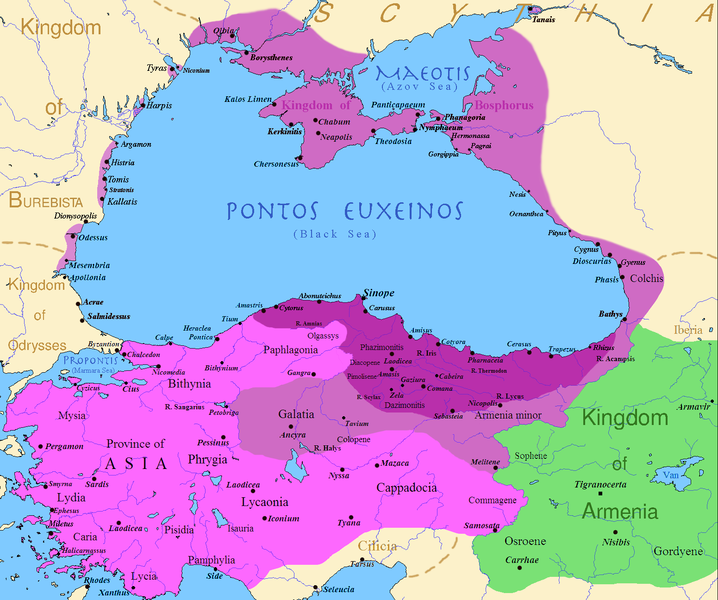
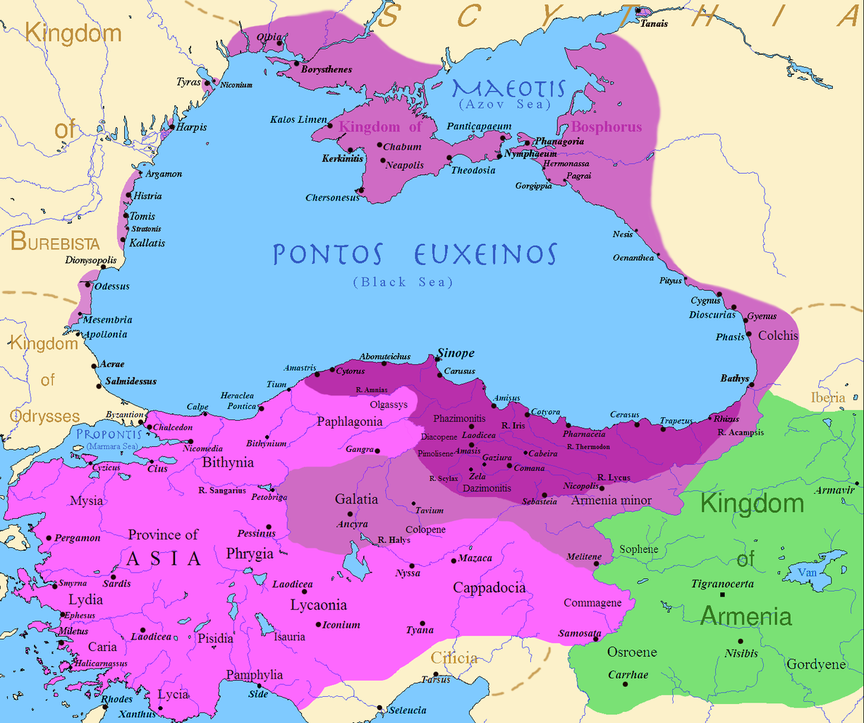
English: Map of the Kingdom of Pontus, Before the reign of Mithridates VI (darkest purple), after his conquests (purple), and his conquests in the first Mithridatic wars (pink); little adds (ancient shorelines & some greek colonies under Mithridate's rule) according with V. Yanko-Hombach, A.S. Gilbert, N. Panin, P. M. Dolukhanov: The Black Sea Flood Question: Changes in Coastline, Climate, and Human Settlement, Springer, Netherlands, 2007, and with Appianus, Plutarchus & Strabo. |
| Datum | |
| Bron | I (Javierfv1212 (talk)) created this work entirely by myself. Sources, Cambridge Ancient history volume 9, Penguin atlas of Greek history and the Foreign Policy of Mithridates VI Eupator. |
| Auteur | Javierfv1212 (talk) |
Licentie
| Dit werk vrijgegeven in het publieke domein door de auteur, Javierfv1212 op de Engelstalige Wikipedia. Dit is wereldwijd van toepassing. In sommige landen is dit wettelijk niet mogelijk; in die gevallen geldt: Javierfv1212 staat iedereen toe dit werk voor eender welk doel te gebruiken, zonder enige voorwaarden, tenzij zulke voorwaarden door de wet worden voorgeschreven. |
Oorspronkelijk uploadlogboek
Verplaatst vanaf en.wikipedia naar Commons door Falcorian met behulp van CommonsHelper.
De oorspronkelijke beschrijving van deze afbeelding stond hier. Alle volgende gebruikersnamen verwijzen naar en.wikipedia.
- 2009-07-19 23:42 Javierfv1212 1551×1296× (205182 bytes) {{Information |Description = Map of the Kingdom of Pontus, Before the reign of mithridates VI (darkest purple), after his conquests (purple), and his conquests in the first Mithridatic wars (pink). |Source = I (~~~) created this work entirel
Bestandsgeschiedenis
Klik op een datum/tijd om het bestand te zien zoals het destijds was.
| Datum/tijd | Miniatuur | Afmetingen | Gebruiker | Opmerking | |
|---|---|---|---|---|---|
| huidige versie | 9 dec 2017 04:00 | | 1.551 × 1.296 (265 kB) | SteinsplitterBot | Bot: Image rotated by 90° |
| 9 dec 2017 02:00 |  | 1.296 × 1.551 (316 kB) | SteinsplitterBot | Bot: Image rotated by 270° | |
| 22 sep 2016 19:54 |  | 1.551 × 1.296 (265 kB) | Hohum | Lighten water area | |
| 9 aug 2016 13:21 |  | 1.551 × 1.296 (260 kB) | MAXHO | Details : more cities & shoreline of this time | |
| 1 okt 2015 22:57 |  | 1.551 × 1.296 (249 kB) | Spiridon Ion Cepleanu | Cosmetic again | |
| 30 sep 2015 14:55 |  | 1.551 × 1.296 (247 kB) | Spiridon Ion Cepleanu | Cosmetic colours & background names | |
| 7 apr 2014 16:21 |  | 1.551 × 1.296 (225 kB) | Spiridon Ion Cepleanu | Little changes (ancient shoreline & some greek colonies under Pontic rule) according with V. Yanko-Hombach, A.S. Gilbert, N. Panin, P. M. Dolukhanov: ''The Black Sea Flood Question: Changes in Coastline, Climate, and Human Settlement'', Springer, Nethe... | |
| 20 jul 2009 06:14 |  | 1.551 × 1.296 (200 kB) | File Upload Bot (Magnus Manske) | {{BotMoveToCommons|en.wikipedia|year={{subst:CURRENTYEAR}}|month={{subst:CURRENTMONTHNAME}}|day={{subst:CURRENTDAY}}}} {{Information |Description={{en|Map of the Kingdom of Pontus, Before the reign of mithridates VI (darkest purple), after his conquests |
Bestandsgebruik
Dit bestand wordt op de volgende pagina gebruikt:
Globaal bestandsgebruik
De volgende andere wiki's gebruiken dit bestand:
- Gebruikt op ar.wikipedia.org
- Gebruikt op ast.wikipedia.org
- Gebruikt op azb.wikipedia.org
- Gebruikt op az.wikipedia.org
- Gebruikt op bg.wikipedia.org
- Gebruikt op br.wikipedia.org
- Gebruikt op ca.wikipedia.org
- Gebruikt op cs.wikipedia.org
- Gebruikt op da.wikipedia.org
- Gebruikt op de.wikipedia.org
- Gebruikt op el.wikipedia.org
- Gebruikt op en.wikipedia.org
- Gebruikt op es.wikipedia.org
- Gebruikt op et.wikipedia.org
- Gebruikt op eu.wikipedia.org
- Gebruikt op fa.wikipedia.org
- Gebruikt op fr.wikipedia.org
Globaal gebruik van dit bestand bekijken.