Bestand:Partition of Hungary.png
Geen hogere resolutie beschikbaar.
Partition_of_Hungary.png (389 × 328 pixels, bestandsgrootte: 31 kB, MIME-type: image/png)
| Dit is een bestand van Wikimedia Commons. Onderstaande beschrijving komt van de beschrijving van het bestand daar. |
Beschrijving

| Beschrijving |
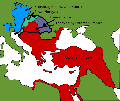
A map displaying position of the Kingdom of Hungary before 1541, and the 3 parts into which it was divided after the occupation of Buda in 1541: Royal Hungary, Eastern Hungarian kingdom, and the part that was annexed by the Ottoman Empire. en:Category:Maps of the history of Hungary |
| Datum | 3 september 2006 (originele uploaddatum) |
| Bron | Verplaatst vanaf en.wikipedia naar Commons. |
| Auteur |
Esoltas op de Engelstalige Wikipedia Later versions were uploaded by PANONIAN, DonatusHR at en.wikipedia. |
Licentie
| Dit werk vrijgegeven in het publieke domein door de auteur, Esoltas op de Engelstalige Wikipedia. Dit is wereldwijd van toepassing. In sommige landen is dit wettelijk niet mogelijk; in die gevallen geldt: Esoltas staat iedereen toe dit werk voor eender welk doel te gebruiken, zonder enige voorwaarden, tenzij zulke voorwaarden door de wet worden voorgeschreven. |
Oorspronkelijk uploadlogboek
De oorspronkelijke beschrijving van deze afbeelding stond hier. Alle volgende gebruikersnamen verwijzen naar en.wikipedia.
- 2007-08-12 15:14 DonatusHR 389×328×8 (38357 bytes) Vraćeno na prijašnju inačicu
- 2007-08-12 15:13 DonatusHR 389×328×8 (35596 bytes) Vraćeno na prijašnju inačicu
- 2006-10-11 10:58 PANONIAN 389×328×8 (38357 bytes) corrected image
- 2006-09-03 15:00 Esoltas 389×328×8 (35596 bytes) A map displaying the original position of the Kingdom of Hungary, and the 3 lands that became of it after the Battle of Mohács: Royal Hungary, Transylvania, and the Ottoman-occupied section.
Bestandsgeschiedenis
Klik op een datum/tijd om het bestand te zien zoals het destijds was.
| Datum/tijd | Miniatuur | Afmetingen | Gebruiker | Opmerking | |
|---|---|---|---|---|---|
| huidige versie | 12 feb 2016 19:22 | | 389 × 328 (31 kB) | Packare | better caption |
| 10 sep 2007 19:58 |  | 389 × 328 (37 kB) | Sir Iain | {{Information |Description=A map displaying position of the Kingdom of Hungary before 1526, and the 3 parts into which it was divided after the Battle of Mohács: Royal Hungary, Transylvania, and the part that was annexed by the Ottoman Empire. [[:en:Ca |
Bestandsgebruik
Dit bestand wordt op de volgende 2 pagina's gebruikt:
Globaal bestandsgebruik
De volgende andere wiki's gebruiken dit bestand:
- Gebruikt op ar.wikipedia.org
- Gebruikt op azb.wikipedia.org
- Gebruikt op de.wikipedia.org
- Gebruikt op el.wikipedia.org
- Gebruikt op en.wikipedia.org
- Gebruikt op es.wikipedia.org
- Gebruikt op fr.wikipedia.org
- Gebruikt op gl.wikipedia.org
- Gebruikt op hu.wikipedia.org
- Gebruikt op io.wikipedia.org
- Gebruikt op it.wikipedia.org
- Gebruikt op ja.wikipedia.org
- Gebruikt op ko.wikipedia.org
- Gebruikt op lv.wikipedia.org
- Gebruikt op sk.wikipedia.org
- Gebruikt op trv.wikipedia.org
- Gebruikt op tr.wikipedia.org
- Gebruikt op uk.wikipedia.org
- Gebruikt op uz.wikipedia.org
- Gebruikt op zh.wikipedia.org