Bestand:PIA19913-MarsLandingSite-Ares3Mission-TheMartian-2015Film-20150517.jpg

Oorspronkelijk bestand (1.280 × 640 pixels, bestandsgrootte: 137 kB, MIME-type: image/jpeg)
| Dit is een bestand van Wikimedia Commons. Onderstaande beschrijving komt van de beschrijving van het bestand daar. |
Beschrijving
| Beschrijving |
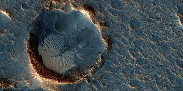
English: PIA19913: The Ares 3 Landing Site: Where Science Fact Meets Fiction
http://photojournal.jpl.nasa.gov/catalog/PIA19913 This image from the High Resolution Imaging Science Experiment (HiRISE) camera on NASA's Mars Reconnaissance Orbiter shows a location on Mars associated with the best-selling novel and Hollywood movie, "The Martian." This area is in the Acidalia Planitia region. In the novel and the movie, it is the landing site of a crewed mission named Ares 3. For the story's central character, Acidalia Planitia is within driving distance from where NASA's Mars Pathfinder, with its Sojourner rover, landed in 1997. An initial HiRISE image of the site was taken in April 2015 and is online at http://hirise.lpl.arizona.edu/ESP_040776_2115. A second one was taken May 17, 2015, and is shown here. Figure 1 is a stereo combination of the two, appearing three-dimensional when viewed through blue-red glasses with the red lens on the left One of the main objectives of the HiRISE camera is to carry out "monitoring science", which involves taking images of certain areas of high scientific interest on regular intervals. The team usually does so to monitor a seasonal or recurring process such as seasonal changes in carbon-dioxide ice near the poles, dune movement or recurring flow-like features on some slopes. HiRISE also takes repeated images of areas with active rovers, such as Curiosity, to help plan safe routes toward areas of high scientific interest. Another key responsibility for the HiRISE camera is to provide information for use in selection of landing sites for future missions. One technique is to image a site of interest at least twice when the weather conditions are similar, but with a small difference in viewing angle, much like what you would experience if you looked at something with only your right eye, then looked at it again with the left. By doing this, we are able to build a stereo view of the site, providing a chance to identify high and low points in the site more effectively. This resulting 3-D information can combined with elevation data from laser altimeters to create a highly accurate "digital terrain model" or DTM for short. DTMs allow researchers to view the locations in 3-D and to analyze them by measuring the exact height of features that could be hazardous to the future mission, such as large boulders or small impact craters. DTMs from HiRISE were a key factor in choosing the landing site for NASA's Curiosity Mars rover in Gale Crater and are being used to evaluate sites under consideration for the NASA's 2016 InSight Mars lander and Mars 2020 rover missions. The location of the site in this image is 31.3 degrees north latitude, 331.3 degrees east latitude. The image is an excerpt from HiRISE observation ESP_041277_2115. The University of Arizona, Tucson, operates HiRISE, which was built by Ball Aerospace & Technologies Corp., Boulder, Colorado. NASA's Jet Propulsion Laboratory, a division of the California Institute of Technology in Pasadena, manages the Mars Reconnaissance Orbiter Project for NASA's Science Mission Directorate, Washington. Lockheed Martin Space Systems, Denver, built the orbiter and collaborates with JPL to operate it. |
| Datum | |
| Bron | http://photojournal.jpl.nasa.gov/jpeg/PIA19913.jpg |
| Auteur | NASA/JPL-Caltech/Univ. of Arizona |
Licentie
| Dit bestand bevindt zich in het publiek domein, omdat het gemaakt is door de NASA. In de reproductierichtlijnen van de NASA staat dat "NASA-materiaal niet beschermd wordt door auteursrecht, tenzij anders vermeld". | ||
 |
Waarschuwingen:
|
Bestandsgeschiedenis
Klik op een datum/tijd om het bestand te zien zoals het destijds was.
| Datum/tijd | Miniatuur | Afmetingen | Gebruiker | Opmerking | |
|---|---|---|---|---|---|
| huidige versie | 6 okt 2015 05:20 | | 1.280 × 640 (137 kB) | Drbogdan | User created page with UploadWizard |
Bestandsgebruik
Dit bestand wordt op de volgende pagina gebruikt:
Globaal bestandsgebruik
De volgende andere wiki's gebruiken dit bestand:
- Gebruikt op an.wikipedia.org
- Gebruikt op de.wikipedia.org
- Gebruikt op en.wikipedia.org
- Gebruikt op eo.wikipedia.org
- Gebruikt op et.wikipedia.org
- Gebruikt op fy.wikipedia.org
- Gebruikt op mk.wikipedia.org
- Gebruikt op ms.wikipedia.org
- Gebruikt op ro.wikipedia.org
- Gebruikt op zh.wikipedia.org