Bestand:Orleans County (New York) - Towns and Villages.svg

Afmetingen van deze voorvertoning van het type PNG van dit SVG-bestand: 800 × 587 pixels Andere resoluties: 320 × 235 pixels | 640 × 469 pixels | 1.024 × 751 pixels | 1.280 × 939 pixels | 2.560 × 1.877 pixels | 1.500 × 1.100 pixels.
Oorspronkelijk bestand (SVG-bestand, nominaal 1.500 × 1.100 pixels, bestandsgrootte: 28 kB)
| Dit is een bestand van Wikimedia Commons. Onderstaande beschrijving komt van de beschrijving van het bestand daar. |
_-_Towns_and_Villages.svg)
Beschrijving
| Beschrijving |
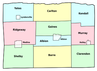
English: Map of Orleans County, New York, showing its constituent towns and villages. Labels in English. |
| Datum | |
| Bron | Own work by uploader, based on public domain USGS topographic maps |
| Auteur | LtPowers |
| Andere versies | Image:Orleans County (New York) outline.jpg |
_outline.jpg&action=edit&redlink=1)
Deze niet W3C-verklaarde vectorafbeelding is gemaakt met Inkscape .
Licentie
Ik, de auteursrechthebbende van dit werk, maak het hierbij onder de volgende licentie beschikbaar:
Dit bestand is gelicenseerd onder de Creative Commons-licentie Naamsvermelding-Gelijk delen 3.0 Unported
- De gebruiker mag:
- Delen – het werk kopiëren, verspreiden en doorgeven
- Remixen – afgeleide werken maken
- Onder de volgende voorwaarden:
- naamsvermelding – U moet op een gepaste manier aan naamsvermelding doen, een link naar de licentie geven, en aangeven of er wijzigingen in het werk zijn aangebracht. U mag dit op elke redelijke manier doen, maar niet zodanig dat de indruk wordt gewekt dat de licentiegever instemt met uw werk of uw gebruik van zijn werk.
- Gelijk delen – Als u het werk heeft geremixt, veranderd, of erop heeft voortgebouwd, moet u het gewijzigde materiaal verspreiden onder dezelfde licentie als het oorspronkelijke werk, of een daarmee compatibele licentie.
Bestandsgeschiedenis
Klik op een datum/tijd om het bestand te zien zoals het destijds was.
| Datum/tijd | Miniatuur | Afmetingen | Gebruiker | Opmerking | |
|---|---|---|---|---|---|
| huidige versie | 11 nov 2008 23:46 | | 1.500 × 1.100 (28 kB) | LtPowers | change village labels to condensed and increase point size accordingly |
| 11 nov 2008 23:38 |  | 1.500 × 1.100 (28 kB) | LtPowers | reduce lower margin | |
| 11 nov 2008 23:27 |  | 1.500 × 1.500 (28 kB) | LtPowers | {{Information |Description={{en|1=Map of Orleans County, New York, showing its constituent towns and villages. Labels in English.}} |Source=Own work by uploader, based on public domain USGS topographic maps |Author=[[User:L |
Bestandsgebruik
Dit bestand wordt op de volgende pagina gebruikt:
Globaal bestandsgebruik
De volgende andere wiki's gebruiken dit bestand:
- Gebruikt op en.wikipedia.org
- Orleans County, New York
- Oak Orchard State Marine Park
- Lakeside Beach State Park
- Barre Center, New York
- Childs, New York
- Template:OrleansCountyNY-geo-stub
- Millers, New York
- Oak Orchard, New York
- Millville, New York
- Hulberton, New York
- Kent, Orleans County, New York
- Knowlesville, New York
- Waterport, New York
- Sawyer, Orleans County, New York
- East Gaines, New York
- Gebruikt op es.wikipedia.org
- Gebruikt op fr.wikipedia.org
- Gebruikt op ja.wikipedia.org
- Gebruikt op www.wikidata.org
_-_Towns_and_Villages.svg)