Bestand:NorthamptonshireWellingborough.png
Geen hogere resolutie beschikbaar.
NorthamptonshireWellingborough.png (200 × 222 pixels, bestandsgrootte: 14 kB, MIME-type: image/png)
| Dit is een bestand van Wikimedia Commons. Onderstaande beschrijving komt van de beschrijving van het bestand daar. |
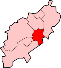
Wellingborough in Northamptonshire
Created by en:User:Morwen

|
Toestemming wordt verleend voor het kopiëren, verspreiden en/of wijzigen van dit document onder de voorwaarden van de GNU-licentie voor vrije documentatie, versie 1.2 of enige latere versie als gepubliceerd door de Free Software Foundation; zonder Invariant Sections, zonder Front-Cover Texts, en zonder Back-Cover Texts. Een kopie van de licentie is opgenomen in de sectie GNU-licentie voor vrije documentatie. |
| Dit bestand is gelicenseerd onder de Creative Commons-licentie Naamsvermelding-Gelijk delen 3.0 Unported | ||
| ||
| Deze licentietag is toegevoegd aan dit bestand in verband met de GFDL licentie-update. |
Bestandsgeschiedenis
Klik op een datum/tijd om het bestand te zien zoals het destijds was.
| Datum/tijd | Miniatuur | Afmetingen | Gebruiker | Opmerking | |
|---|---|---|---|---|---|
| huidige versie | 24 mei 2006 23:05 | | 200 × 222 (14 kB) | Nichtbesserwisser | Wellingborough in Northamptonshire Created by en:User:Morwen {{GFDL}} Category:Maps of districts in East Midlands |
Bestandsgebruik
Dit bestand wordt op de volgende pagina gebruikt:
Globaal bestandsgebruik
De volgende andere wiki's gebruiken dit bestand:
- Gebruikt op bg.wikipedia.org
- Gebruikt op de.wikipedia.org
- Gebruikt op en.wikipedia.org
- Sywell Aerodrome
- Sywell
- Wellingborough
- Borough of Wellingborough
- Wollaston, Northamptonshire
- Grendon, Northamptonshire
- Wellingborough School
- Easton Maudit
- Wilby, Northamptonshire
- Isham
- Wellingborough (UK Parliament constituency)
- Mears Ashby
- Finedon
- Wellingborough railway station
- Ecton, Northamptonshire
- Great Doddington
- Strixton
- A509 road
- Earls Barton
- Bozeat
- Wellingborough Whitworth F.C.
- Wellingborough Town F.C.
- Irchester
- Redhill Grange
- Orlingbury
- Great Harrowden
- Little Harrowden
- Tresham College of Further and Higher Education
- The Castle Theatre, Wellingborough
- Hardwick, Northamptonshire
- Template:BC Wellingborough
- Gebruikt op fa.wikipedia.org
- Gebruikt op it.wikipedia.org
- Gebruikt op no.wikipedia.org
- Gebruikt op ro.wikipedia.org