Bestand:Maro map lrg.gif
Geen hogere resolutie beschikbaar.
Maro_map_lrg.gif (600 × 547 pixels, bestandsgrootte: 17 kB, MIME-type: image/gif)
| Dit is een bestand van Wikimedia Commons. Onderstaande beschrijving komt van de beschrijving van het bestand daar. |
Beschrijving
| Beschrijving |
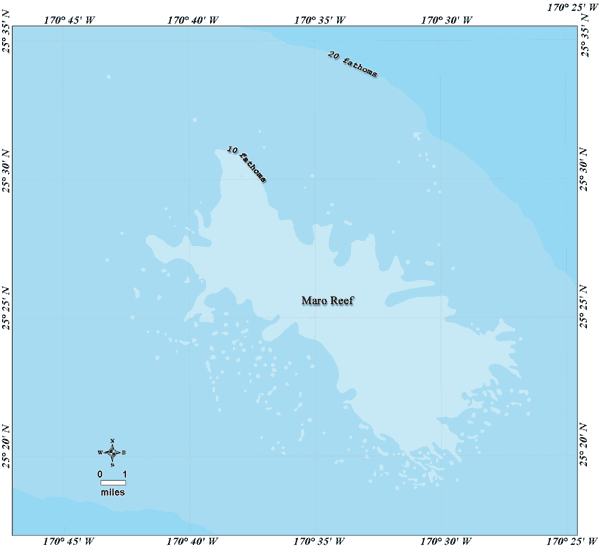
Deutsch: Bathymetrische Karte des Maroriffs, Nordwestliche Hawaii-Inseln
English: Bathymetric map of Maro Reef, Northwestern Hawaiian Islands |
| Datum | not specified |
| Bron | http://www.hawaiireef.noaa.gov/imagery/graphicmaps.html |
| Auteur | Christine Taylor, NOAA's National Marine Sanctuary Program |
| Toestemming (Hergebruik van dit bestand) |
credit to NOAA is preferred |
Licentie
Deze afbeelding is in het publiek domein omdat het materiaal bevat dat oorspronkelijk van de National Oceanic and Atmospheric Administration kwam in de Verenigde Staten en genomen of gemaakt is tijdens de officiële werkzaamheden van een werknemer.
|
Bestandsgeschiedenis
Klik op een datum/tijd om het bestand te zien zoals het destijds was.
| Datum/tijd | Miniatuur | Afmetingen | Gebruiker | Opmerking | |
|---|---|---|---|---|---|
| huidige versie | 20 aug 2008 13:25 | | 600 × 547 (17 kB) | Telim tor | == Information == {{Information |Description= {{de|Bathymetrische Karte des Maroriffs, Nordwestliche Hawaii-Inseln}} {{en|Bathymetric map of Maro Reef, Northwestern Hawaiian Islands}} |Source=http://www.hawaiireef.noaa.gov/imagery/graphicmaps.html |Date=u |
Bestandsgebruik
Dit bestand wordt op de volgende pagina gebruikt:
Globaal bestandsgebruik
De volgende andere wiki's gebruiken dit bestand:
- Gebruikt op ceb.wikipedia.org
- Gebruikt op de.wikipedia.org
- Gebruikt op eo.wikipedia.org
- Gebruikt op frr.wikipedia.org
- Gebruikt op ja.wikipedia.org
- Gebruikt op pl.wikipedia.org
- Gebruikt op pt.wikipedia.org
- Gebruikt op ru.wikipedia.org
- Gebruikt op vi.wikipedia.org
- Gebruikt op zh.wikipedia.org