Bestand:Marine protected areas detailed map.jpg
Grootte van deze voorvertoning: 800 × 486 pixels. Andere resoluties: 320 × 194 pixels | 640 × 389 pixels | 1.024 × 622 pixels | 1.280 × 777 pixels | 2.560 × 1.554 pixels | 4.200 × 2.550 pixels.
Oorspronkelijk bestand (4.200 × 2.550 pixels, bestandsgrootte: 1,18 MB, MIME-type: image/jpeg)
| Dit is een bestand van Wikimedia Commons. Onderstaande beschrijving komt van de beschrijving van het bestand daar. |
Beschrijving
| Beschrijving |
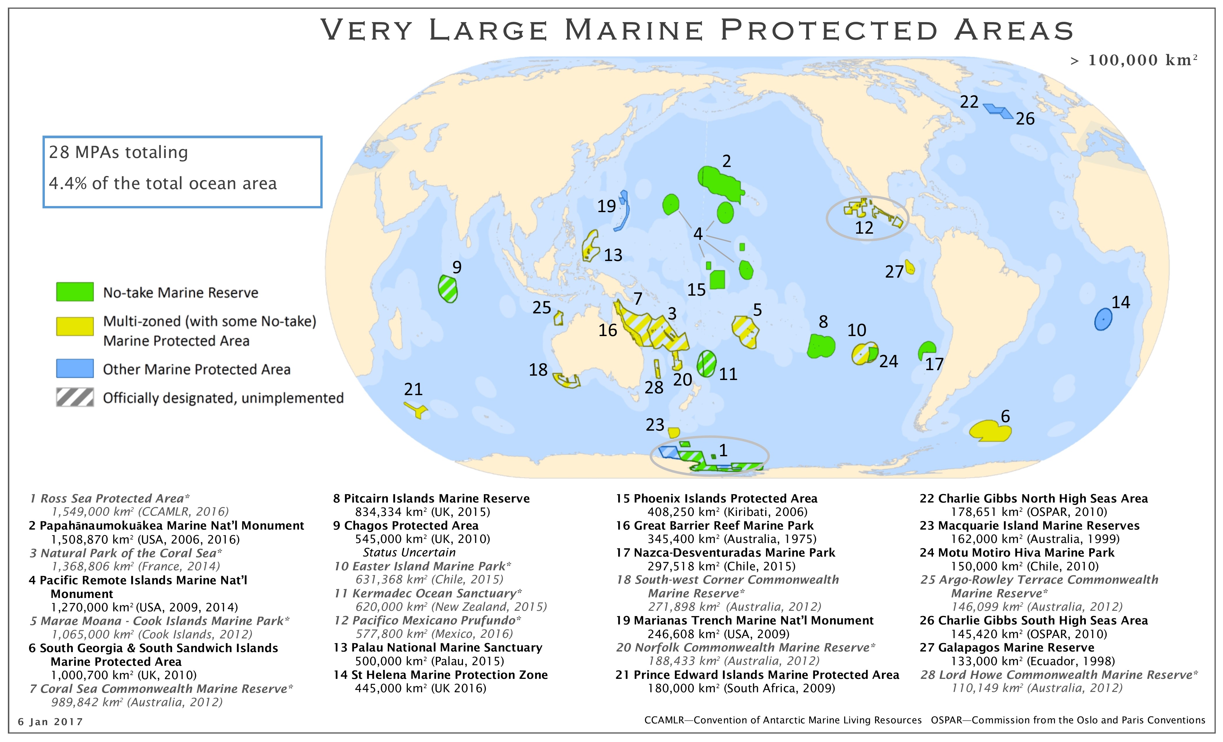
English: Map of the marine protected areas as of 01/2017 |
| Datum | |
| Bron | http://imperative-mooc.magnetised.net/monitoring-the-oceans-from-space/week-5-oceans-and-us/topic-5a-policy/marine-protected-areas-detailed-map |
| Auteur | MPAtlas.org / Marine Conservation Institute |
| Toestemming (Hergebruik van dit bestand) |
Licentie
Dit bestand is gelicenseerd onder de Creative Commons Naamsvermelding-GelijkDelen 4.0 Internationaal licentie.
- De gebruiker mag:
- Delen – het werk kopiëren, verspreiden en doorgeven
- Remixen – afgeleide werken maken
- Onder de volgende voorwaarden:
- naamsvermelding – U moet op een gepaste manier aan naamsvermelding doen, een link naar de licentie geven, en aangeven of er wijzigingen in het werk zijn aangebracht. U mag dit op elke redelijke manier doen, maar niet zodanig dat de indruk wordt gewekt dat de licentiegever instemt met uw werk of uw gebruik van zijn werk.
- Gelijk delen – Als u het werk heeft geremixt, veranderd, of erop heeft voortgebouwd, moet u het gewijzigde materiaal verspreiden onder dezelfde licentie als het oorspronkelijke werk, of een daarmee compatibele licentie.
Bestandsgeschiedenis
Klik op een datum/tijd om het bestand te zien zoals het destijds was.
| Datum/tijd | Miniatuur | Afmetingen | Gebruiker | Opmerking | |
|---|---|---|---|---|---|
| huidige versie | 12 jan 2017 08:22 | | 4.200 × 2.550 (1,18 MB) | Hedwig in Washington | {{Information |Description ={{en|1=Map of the marine protected areas as of 10/2016}} |Source =http://imperative-mooc.magnetised.net/monitoring-the-oceans-from-space/week-5-oceans-and-us/topic-5a-policy/marine-protected-areas-detailed-map |Au... |
Bestandsgebruik
Dit bestand wordt op de volgende pagina gebruikt:
Globaal bestandsgebruik
De volgende andere wiki's gebruiken dit bestand:
- Gebruikt op ar.wikipedia.org
- Gebruikt op cy.wikipedia.org
- Gebruikt op de.wikipedia.org
- Gebruikt op en.wikipedia.org
- Gebruikt op et.wikipedia.org
- Gebruikt op fr.wikipedia.org
- Gebruikt op gd.wikipedia.org
- Gebruikt op it.wikipedia.org
- Gebruikt op ko.wikipedia.org
- Gebruikt op lv.wikipedia.org
- Gebruikt op pt.wikipedia.org
- Gebruikt op sl.wikipedia.org
- Gebruikt op www.wikidata.org