Bestand:Map of the Territory of the Brigantes.svg

Afmetingen van deze voorvertoning van het type PNG van dit SVG-bestand: 424 × 600 pixels Andere resoluties: 170 × 240 pixels | 339 × 480 pixels | 543 × 768 pixels | 724 × 1.024 pixels | 1.448 × 2.048 pixels | 744 × 1.052 pixels.
Oorspronkelijk bestand (SVG-bestand, nominaal 744 × 1.052 pixels, bestandsgrootte: 149 kB)
| Dit is een bestand van Wikimedia Commons. Onderstaande beschrijving komt van de beschrijving van het bestand daar. |
| Beschrijving |
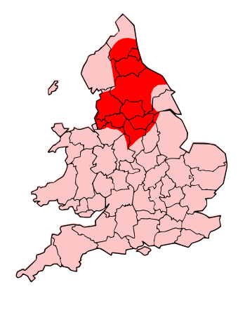
English: County map of England & Wales, overlaid with Territory of the Romano-British Brigantes Tribe of Northern England. |
| Datum | (UTC) |
| Bron | |
| Auteur |
|
| Toestemming (Hergebruik van dit bestand) |
Ik, de auteursrechthebbende van dit werk, maak het hierbij onder de volgende licentie beschikbaar: Dit bestand is gelicenseerd onder de Creative Commons-licentie Naamsvermelding-Gelijk delen 3.0 Unported
|
| Andere versies | Afgeleide werken van dit bestand: Map of the Territory of the Carvetii.svg |
| Dit is een geretoucheerde foto, wat betekent dat de originele versie digitaal aangepast is. Aanpassingen: Revised to show territory of the Brigantes. Het origineel kan hier bekeken worden: England Celtic tribes - North and Midlands.png. Aanpassingen gedaan door Jpb1301.
|
Oorspronkelijk uploadlogboek
This image is a derivative work of the following images:
- File:England_Celtic_tribes_-_North_and_Midlands.png licensed with Cc-by-sa-3.0
- 2009-07-29T23:43:34Z Thomas Gun 296x495 (27459 Bytes) == Summary == {{Information |Description=Image depicting the Celts of North and Midland England, pre-[[Roman Britain]] times. I created this myself, under the guidance (to find location of them) of [http://www.roman-britain.o
Uploaded with derivativeFX
Bestandsgeschiedenis
Klik op een datum/tijd om het bestand te zien zoals het destijds was.
| Datum/tijd | Miniatuur | Afmetingen | Gebruiker | Opmerking | |
|---|---|---|---|---|---|
| huidige versie | 16 okt 2009 22:25 | | 744 × 1.052 (149 kB) | Jpb1301 | {{Information |Description=County map of England & Wales, overlaid with Territory of the Romano-British Brigantes Tribe of Northern England. |Source=*File:England_Celtic_tribes_-_North_and_Midlands.png |Date=2009-10-16 20:19 (UTC) |Author=*[[:File:E |
Bestandsgebruik
Dit bestand wordt op de volgende pagina gebruikt:
Globaal bestandsgebruik
De volgende andere wiki's gebruiken dit bestand:
- Gebruikt op bg.wikipedia.org
- Gebruikt op br.wikipedia.org
- Gebruikt op ca.wikipedia.org
- Gebruikt op cy.wikipedia.org
- Gebruikt op de.wikipedia.org
- Gebruikt op en.wikipedia.org
- Gebruikt op es.wikipedia.org
- Gebruikt op eu.wikipedia.org
- Gebruikt op fi.wikipedia.org
- Gebruikt op fr.wikipedia.org
- Gebruikt op fy.wikipedia.org
- Gebruikt op id.wikipedia.org
- Gebruikt op ka.wikipedia.org
- Gebruikt op ko.wikipedia.org
- Gebruikt op la.wikipedia.org
- Gebruikt op nds.wikipedia.org
- Gebruikt op nn.wikipedia.org
- Gebruikt op no.wikipedia.org
- Gebruikt op ru.wikipedia.org
- Gebruikt op sh.wikipedia.org
- Gebruikt op simple.wikipedia.org
- Gebruikt op sr.wikipedia.org
- Gebruikt op xmf.wikipedia.org