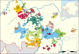
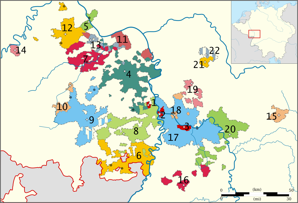
Bestand:Map of the Oberämter of the Electoral Palatinate (1789) - Numbered.svg

Afmetingen van deze voorvertoning van het type PNG van dit SVG-bestand: 800 × 545 pixels Andere resoluties: 320 × 218 pixels | 640 × 436 pixels | 1.024 × 698 pixels | 1.280 × 873 pixels | 2.560 × 1.745 pixels | 3.770 × 2.570 pixels.
Oorspronkelijk bestand (SVG-bestand, nominaal 3.770 × 2.570 pixels, bestandsgrootte: 532 kB)
| Dit is een bestand van Wikimedia Commons. Onderstaande beschrijving komt van de beschrijving van het bestand daar. |
_-_Numbered.svg)
Beschrijving
| Beschrijving |
English: Map of the administrative divisions (Oberämter) and subdivisions of the Electorate of the Palatinate in 1789.
Deutsch: Karte der Kurpfalz 1789.
Stadtämter:
Oberämter:
|
| Datum | |
| Bron | Eigen werk, based on a map from the Heidelberg University website. Orginal from Pfalzatlas. |
| Auteur | Universität Heidelberg, reworked by Sir Iain and Lencer (Inset map of the Empire) |
| Toestemming (Hergebruik van dit bestand) |
Copyright: Universität Heidelberg (see: https://www.uni-heidelberg.de/fakultaeten/philosophie/zegk/vlgk/orte/gemeinden.html) |
Licentie
Ik, de auteursrechthebbende van dit werk, maak het hierbij onder de volgende licenties beschikbaar:
Dit bestand is gelicenseerd onder de Creative Commons-licentie Naamsvermelding-Gelijk delen 3.0 Unported
- De gebruiker mag:
- Delen – het werk kopiëren, verspreiden en doorgeven
- Remixen – afgeleide werken maken
- Onder de volgende voorwaarden:
- naamsvermelding – U moet op een gepaste manier aan naamsvermelding doen, een link naar de licentie geven, en aangeven of er wijzigingen in het werk zijn aangebracht. U mag dit op elke redelijke manier doen, maar niet zodanig dat de indruk wordt gewekt dat de licentiegever instemt met uw werk of uw gebruik van zijn werk.
- Gelijk delen – Als u het werk heeft geremixt, veranderd, of erop heeft voortgebouwd, moet u het gewijzigde materiaal verspreiden onder dezelfde licentie als het oorspronkelijke werk, of een daarmee compatibele licentie.

|
Toestemming wordt verleend voor het kopiëren, verspreiden en/of wijzigen van dit document onder de voorwaarden van de GNU-licentie voor vrije documentatie, versie 1.2 of enige latere versie als gepubliceerd door de Free Software Foundation; zonder Invariant Sections, zonder Front-Cover Texts, en zonder Back-Cover Texts. Een kopie van de licentie is opgenomen in de sectie GNU-licentie voor vrije documentatie. |
U mag zelf één van de licenties kiezen.
Bestandsgeschiedenis
Klik op een datum/tijd om het bestand te zien zoals het destijds was.
| Datum/tijd | Miniatuur | Afmetingen | Gebruiker | Opmerking | |
|---|---|---|---|---|---|
| huidige versie | 12 nov 2010 16:41 | | 3.770 × 2.570 (532 kB) | Sir Iain | {{Information |Description={{en|1=Map of the Political subdivisions (''Oberämter'') of the Electoral Palatinate in 1789.}} |Source={{own}}, based on a map from [http://www.uni-heidelberg.de/fakultaeten/philosophie/zegk/fpi/karte.html the Heidelberg Unive |
Bestandsgebruik
Dit bestand wordt op de volgende pagina gebruikt:
Globaal bestandsgebruik
De volgende andere wiki's gebruiken dit bestand:
- Gebruikt op bg.wikipedia.org
- Gebruikt op ca.wikipedia.org
- Gebruikt op de.wikipedia.org
- Gebruikt op en.wikipedia.org
- Gebruikt op eo.wikipedia.org
- Gebruikt op es.wikipedia.org
- Gebruikt op et.wikipedia.org
- Gebruikt op he.wikipedia.org
- Gebruikt op id.wikipedia.org
- Gebruikt op it.wikipedia.org
- Gebruikt op ja.wikipedia.org
- Gebruikt op no.wikipedia.org
- Gebruikt op pt.wikipedia.org
- Gebruikt op sh.wikipedia.org
- Gebruikt op sv.wikipedia.org
- Gebruikt op vi.wikipedia.org
_-_Numbered.svg)