Bestand:Map of the Electoral Palatinate (1329).svg

Afmetingen van deze voorvertoning van het type PNG van dit SVG-bestand: 549 × 600 pixels Andere resoluties: 220 × 240 pixels | 439 × 480 pixels | 703 × 768 pixels | 937 × 1.024 pixels | 1.875 × 2.048 pixels | 865 × 945 pixels.
Oorspronkelijk bestand (SVG-bestand, nominaal 865 × 945 pixels, bestandsgrootte: 260 kB)
| Dit is een bestand van Wikimedia Commons. Onderstaande beschrijving komt van de beschrijving van het bestand daar. |
.svg)
Beschrijving
| Beschrijving |
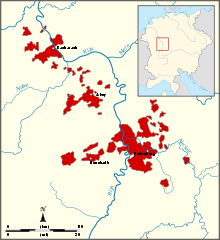
English: Map of the Electorate of the Palatinate in 1329. The upper-Palatinate is not displayed. |
| Datum | |
| Bron | Eigen werk, based on a map in Kleine Geschichte der Kurpfalz by A.Kohnle |
| Auteur | Sir Iain |
Licentie
Ik, de auteursrechthebbende van dit werk, maak het hierbij onder de volgende licenties beschikbaar:
Dit bestand is gelicenseerd onder de Creative Commons-licentie Naamsvermelding-Gelijk delen 3.0 Unported
- De gebruiker mag:
- Delen – het werk kopiëren, verspreiden en doorgeven
- Remixen – afgeleide werken maken
- Onder de volgende voorwaarden:
- naamsvermelding – U moet op een gepaste manier aan naamsvermelding doen, een link naar de licentie geven, en aangeven of er wijzigingen in het werk zijn aangebracht. U mag dit op elke redelijke manier doen, maar niet zodanig dat de indruk wordt gewekt dat de licentiegever instemt met uw werk of uw gebruik van zijn werk.
- Gelijk delen – Als u het werk heeft geremixt, veranderd, of erop heeft voortgebouwd, moet u het gewijzigde materiaal verspreiden onder dezelfde licentie als het oorspronkelijke werk, of een daarmee compatibele licentie.

|
Toestemming wordt verleend voor het kopiëren, verspreiden en/of wijzigen van dit document onder de voorwaarden van de GNU-licentie voor vrije documentatie, versie 1.2 of enige latere versie als gepubliceerd door de Free Software Foundation; zonder Invariant Sections, zonder Front-Cover Texts, en zonder Back-Cover Texts. Een kopie van de licentie is opgenomen in de sectie GNU-licentie voor vrije documentatie. |
U mag zelf één van de licenties kiezen.
Bestandsgeschiedenis
Klik op een datum/tijd om het bestand te zien zoals het destijds was.
| Datum/tijd | Miniatuur | Afmetingen | Gebruiker | Opmerking | |
|---|---|---|---|---|---|
| huidige versie | 17 okt 2010 00:47 | | 865 × 945 (260 kB) | Sir Iain | {{Information |Description={{en|1=Map of the Electoral Palatiate in 1329. The upper-Palatinate is not displayed.}} |Source={{own}}, based on a map in Kleine Geschichte der Kurpfalz by A.Kohnle |Author=Sir Iain |Date=2010-10-17 |Permissio |
Bestandsgebruik
Dit bestand wordt op de volgende pagina gebruikt:
Globaal bestandsgebruik
De volgende andere wiki's gebruiken dit bestand:
- Gebruikt op af.wikipedia.org
- Gebruikt op cs.wikipedia.org
- Gebruikt op de.wikipedia.org
- Gebruikt op en.wikipedia.org
- Gebruikt op hu.wikipedia.org
- Gebruikt op it.wikipedia.org
- Gebruikt op ko.wikipedia.org
- Gebruikt op ro.wikipedia.org
- Gebruikt op sl.wikipedia.org
.svg)