Bestand:Map of Woolwich, 1740s.jpg

Grootte van deze voorvertoning: 485 × 600 pixels. Andere resoluties: 194 × 240 pixels | 388 × 480 pixels | 621 × 768 pixels | 828 × 1.024 pixels | 1.918 × 2.372 pixels.
Oorspronkelijk bestand (1.918 × 2.372 pixels, bestandsgrootte: 4 MB, MIME-type: image/jpeg)
| Dit is een bestand van Wikimedia Commons. Onderstaande beschrijving komt van de beschrijving van het bestand daar. |
Beschrijving
| Beschrijving |
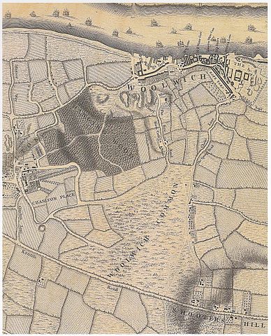
English: Woolwich in the 1740s. Detail of a map of London in the 18th c. Engraved by Richard Parr, surveyed and published by John Rocque, 1746. |
| Datum | |
| Bron | Saint, A., Guillery, P. (ed.), Woolwich – Survey of London, Volume 48, p. 11. Yale Books, London, 2012. ISBN 978 0 300 18722 9 |
| Auteur | John Rocque (c. 1709–1762) |
| Andere versies |
.jpg)
Licentie
|
Dit werk bevindt zich in het publiek domein in landen en gebieden waar de auteursrechttermijn het leven van de auteur plus 100 jaar of minder is. | |
| Van dit bestand is vastgesteld dat er geen bekende auteursrechtaanspraken op rusten, alle aanverwante en naburige rechten daarbij inbegrepen. | |
Bestandsgeschiedenis
Klik op een datum/tijd om het bestand te zien zoals het destijds was.
| Datum/tijd | Miniatuur | Afmetingen | Gebruiker | Opmerking | |
|---|---|---|---|---|---|
| huidige versie | 15 mrt 2017 14:12 | | 1.918 × 2.372 (4 MB) | Kleon3 | User created page with UploadWizard |
Bestandsgebruik
Geen enkele pagina gebruikt dit bestand.