Bestand:Map CZ - district Praha-vychod.PNG

Grootte van deze voorvertoning: 800 × 548 pixels. Andere resoluties: 320 × 219 pixels | 640 × 439 pixels | 1.024 × 702 pixels | 1.281 × 878 pixels.
Oorspronkelijk bestand (1.281 × 878 pixels, bestandsgrootte: 37 kB, MIME-type: image/png)
| Dit is een bestand van Wikimedia Commons. Onderstaande beschrijving komt van de beschrijving van het bestand daar. |
Beschrijving
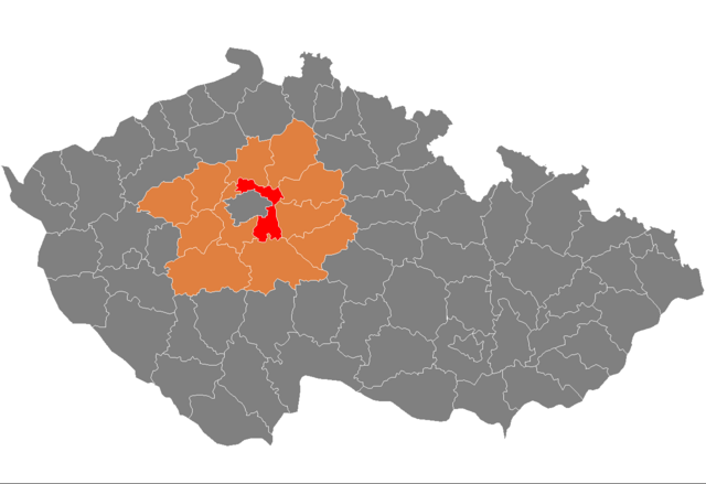
| Beschrijving | Location of Prague-East District in Central Bohemian Region and the Czech Republic. The map shows extent of the district as until December 31, 2006. |
| Datum | Datum onbekend |
| Bron | self-made, based on Image:Czech_Republic_districts.png |
| Auteur | Michiel1972 |
Licentie
| Ik, de auteursrechthebbende van dit werk, geef dit werk vrij in het publieke domein. Dit is wereldwijd van toepassing. In sommige landen is dit wettelijk niet mogelijk; in die gevallen geldt: Ik sta iedereen toe dit werk voor eender welk doel te gebruiken, zonder enige voorwaarden, tenzij zulke voorwaarden door de wet worden voorgeschreven. |
Bestandsgeschiedenis
Klik op een datum/tijd om het bestand te zien zoals het destijds was.
| Datum/tijd | Miniatuur | Afmetingen | Gebruiker | Opmerking | |
|---|---|---|---|---|---|
| huidige versie | 5 okt 2007 11:05 | | 1.281 × 878 (37 kB) | Michiel1972 | {{Information |Description=Locator_maps_of_districts_of_the_Czech_Republic. |Source=self-made, based on Image:Czech_Republic_districts.png |Date= |Author= Michiel1972 }} [[category:Locator_maps_of_districts_of_the_Czech_Republic |
Bestandsgebruik
Dit bestand wordt op de volgende pagina gebruikt:
Globaal bestandsgebruik
De volgende andere wiki's gebruiken dit bestand:
- Gebruikt op ar.wikipedia.org
- Gebruikt op azb.wikipedia.org
- Gebruikt op bg.wikipedia.org
- Gebruikt op de.wikipedia.org
- Gebruikt op en.wikipedia.org
- Gebruikt op eo.wikipedia.org
- Gebruikt op fa.wikipedia.org
- Gebruikt op fr.wikipedia.org
- Gebruikt op hu.wikipedia.org
- Gebruikt op it.wikipedia.org
- Gebruikt op ka.wikipedia.org
- Gebruikt op ms.wikipedia.org
- Gebruikt op pl.wikipedia.org
- Gebruikt op pnb.wikipedia.org
- Gebruikt op pt.wikipedia.org
- Brandýs nad Labem-Stará Boleslav
- Říčany
- Čelákovice
- Predefinição:Distrito de Praha-východ
- Klecany
- Kostelec nad Černými lesy
- Mnichovice
- Odolena Voda
- Úvaly
- Lázně Toušeň
- Nehvizdy
- Škvorec
- Zápy
- Babice (Boêmia Central)
- Bašť
- Borek (Boêmia Central)
- Bořanovice
- Brázdim
- Březí (Boêmia Central)
- Černé Voděrady
- Čestlice
- Dobročovice
- Dobřejovice
- Doubek
- Dřevčice
- Dřísy
- Herink
- Hlavenec
- Horoušany
- Hovorčovice
- Hrusice
- Husinec (Boêmia Central)
- Jenštejn
- Jevany
- Jirny
- Kaliště (Boêmia Central)
Globaal gebruik van dit bestand bekijken.