Bestand:LondonBrent.png
Geen hogere resolutie beschikbaar.
LondonBrent.png (200 × 155 pixels, bestandsgrootte: 23 kB, MIME-type: image/png)
| Dit is een bestand van Wikimedia Commons. Onderstaande beschrijving komt van de beschrijving van het bestand daar. |
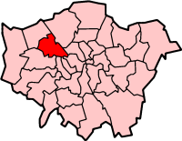
London Borough of Brent
Map drawn by en:User:Morwen

|
Toestemming wordt verleend voor het kopiëren, verspreiden en/of wijzigen van dit document onder de voorwaarden van de GNU-licentie voor vrije documentatie, versie 1.2 of enige latere versie als gepubliceerd door de Free Software Foundation; zonder Invariant Sections, zonder Front-Cover Texts, en zonder Back-Cover Texts. Een kopie van de licentie is opgenomen in de sectie GNU-licentie voor vrije documentatie. |
| Dit bestand is gelicenseerd onder de Creative Commons-licentie Naamsvermelding-Gelijk delen 3.0 Unported | ||
| ||
| Deze licentietag is toegevoegd aan dit bestand in verband met de GFDL licentie-update. |
Bestandsgeschiedenis
Klik op een datum/tijd om het bestand te zien zoals het destijds was.
| Datum/tijd | Miniatuur | Afmetingen | Gebruiker | Opmerking | |
|---|---|---|---|---|---|
| huidige versie | 9 apr 2005 11:56 | | 200 × 155 (23 kB) | Voyager | London Borough of Brent Map drawn by en:User:Morwen {{GFDL}} Category:Maps of London |
Bestandsgebruik
Dit bestand wordt op de volgende pagina gebruikt:
Globaal bestandsgebruik
De volgende andere wiki's gebruiken dit bestand:
- Gebruikt op ar.wikipedia.org
- Gebruikt op da.wikipedia.org
- Gebruikt op en.wikipedia.org
- Alperton
- Brondesbury
- Cricklewood
- Harlesden
- Kensal Green
- Kenton, London
- Kilburn, London
- Kingsbury, London
- Neasden
- London Borough of Brent
- Wembley
- Willesden
- Dollis Hill
- Dollis Hill tube station
- Burnt Oak
- Wembley Park
- Colindale
- Queen's Park, London
- Paddock (war rooms)
- Parks and open spaces in the London Borough of Brent
- North Wembley
- Park Royal
- Sudbury, London
- Stonebridge, London
- Mapesbury
- Queensbury, London
- Brondesbury Park
- Preston, London
- Brent Park, Neasden
- Roe Green Park
- Template:LB Brent
- Tokyngton
- Fryent Country Park
- Category:London Borough of Brent
- List of public art in the London Borough of Brent
- St Raphael's Estate
- Church End, Brent
- Chalkhill Estate
- List of people from the London Borough of Brent
- The Library at Willesden Green
- Grade I and II* listed buildings in the London Borough of Brent
- Brent Civic Centre
- Wikipedia:WikiProject Navigation templates/Country subdivisions/United Kingdom/England
- London Designer Outlet
- User:Victor P./sandbox3
- Gebruikt op fr.wikipedia.org
Globaal gebruik van dit bestand bekijken.