Bestand:LauIslandsMap.JPG
Geen hogere resolutie beschikbaar.
LauIslandsMap.JPG (332 × 385 pixels, bestandsgrootte: 26 kB, MIME-type: image/jpeg)
| Dit is een bestand van Wikimedia Commons. Onderstaande beschrijving komt van de beschrijving van het bestand daar. |
Beschrijving
| Beschrijving |
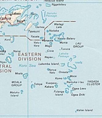
Čeština: Mapa Souostroví Lau.
Bahasa Indonesia: Kepulauan Lau.
English: Lau Islands Map. |
| Datum | 6 oktober 2005 (originele uploaddatum) |
| Bron | http://www.lib.utexas.edu/maps/islands_oceans_poles/fiji.jpg |
| Auteur | CIA World Factbook map |
| Andere versies |

Licentie
Deze afbeelding bevindt zich in het publiek domein omdat het materiaal bevat dat oorspronkelijk afkomstig is van het CIA World Factbook.
|
 |
Oorspronkelijk uploadlogboek
All following user names refer to en.wikipedia.
- 2005-10-06 20:52 Polylerus 332×385×8 (26427 bytes) {{PD-PCL}}
Bestandsgeschiedenis
Klik op een datum/tijd om het bestand te zien zoals het destijds was.
| Datum/tijd | Miniatuur | Afmetingen | Gebruiker | Opmerking | |
|---|---|---|---|---|---|
| huidige versie | 21 feb 2008 13:31 | | 332 × 385 (26 kB) | File Upload Bot (Magnus Manske) | {{BotMoveToCommons|en.wikipedia}} {{Information |Description={{en|''no original description''}} |Source=Transferred from [http://en.wikipedia.org en.wikipedia]; Transfer was stated to be made by User:sevela.p. |Date=2005-10-06 (original upload date) |
Bestandsgebruik
Dit bestand wordt op de volgende 2 pagina's gebruikt:
Globaal bestandsgebruik
De volgende andere wiki's gebruiken dit bestand:
- Gebruikt op ceb.wikipedia.org
- Gebruikt op cs.wikipedia.org
- Gebruikt op de.wikipedia.org
- Gebruikt op en.wikipedia.org
- Gebruikt op eo.wikipedia.org
- Gebruikt op es.wikipedia.org
- Gebruikt op fr.wikipedia.org
- Gebruikt op hif.wikipedia.org
- Gebruikt op id.wikipedia.org
- Gebruikt op ka.wikipedia.org
Globaal gebruik van dit bestand bekijken.