Bestand:King George Island map-en.svg

Afmetingen van deze voorvertoning van het type PNG van dit SVG-bestand: 661 × 403 pixels Andere resoluties: 320 × 195 pixels | 640 × 390 pixels | 1.024 × 624 pixels | 1.280 × 780 pixels | 2.560 × 1.561 pixels.
Oorspronkelijk bestand (SVG-bestand, nominaal 661 × 403 pixels, bestandsgrootte: 209 kB)
| Dit is een bestand van Wikimedia Commons. Onderstaande beschrijving komt van de beschrijving van het bestand daar. |
| Beschrijving |
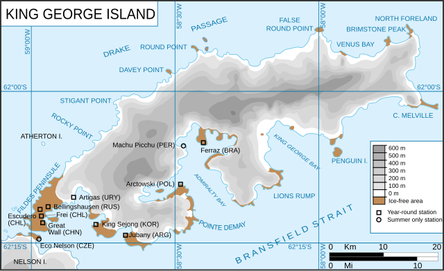
King George Island map. Detailed. Relief. Research Stations. Français : Carte de l'île du Roi-George. Relief et stations de recherches English: King George Island map. Detailed. Relief. Research Stations. |
| Datum | (UTC) |
| Bron | |
| Auteur |
|
| Andere versies |
Afgeleide werken van dit bestand: |
.svg)
.svg)
| Dit is een geretoucheerde foto, wat betekent dat de originele versie digitaal aangepast is. Aanpassingen: english version of the french one. Het origineel kan hier bekeken worden: Ile du roi-George (carte-fr).svg. Aanpassingen gedaan door Treehill.
|
Dit bestand is gelicenseerd onder de Creative Commons-licentie Naamsvermelding-Gelijk delen 3.0 Unported
- De gebruiker mag:
- Delen – het werk kopiëren, verspreiden en doorgeven
- Remixen – afgeleide werken maken
- Onder de volgende voorwaarden:
- naamsvermelding – U moet op een gepaste manier aan naamsvermelding doen, een link naar de licentie geven, en aangeven of er wijzigingen in het werk zijn aangebracht. U mag dit op elke redelijke manier doen, maar niet zodanig dat de indruk wordt gewekt dat de licentiegever instemt met uw werk of uw gebruik van zijn werk.
- Gelijk delen – Als u het werk heeft geremixt, veranderd, of erop heeft voortgebouwd, moet u het gewijzigde materiaal verspreiden onder dezelfde licentie als het oorspronkelijke werk, of een daarmee compatibele licentie.
Oorspronkelijk uploadlogboek
This image is a derivative work of the following images:
- File:Kgeorge_map.png licensed with Cc-by-sa-3.0-migrated, GFDL
- 2008-01-22T13:13:50Z Wadim 660x402 (303141 Bytes) {{Information |Description= King George Island map. Detailed. Relief. Research Stations. Modificado 22.01.2008: Quito la firma, añado denominación historica en ruso. |Source= |Date= 06-May-2006 |Author= Giovanni Fattori |P
- 2006-05-06T17:51:48Z Gi 660x402 (307135 Bytes) {{Information |Description= King George Island map. Detailed. Relief. Research Stations. |Source= |Date= 06-May-2006 |Author= Giovanni Fattori |Permission= GNU free licence |other_versions= }}
- File:Ile_du_roi-George_(carte-fr).svg licensed with Cc-by-sa-3.0-migrated, GFDL
- 2010-04-18T21:10:06Z Trex 661x403 (266284 Bytes) {{Information |Description={{fr|1=Carte de l'île du Roi-George. Relief et stations de recherches}} {{en|1=King George Island map. Detailed. Relief. Research Stations.}} |Source=*[[:File:Kgeorge_map.png|]] |Date=2010-04-18 21:07
Uploaded with derivativeFX
Bestandsgeschiedenis
Klik op een datum/tijd om het bestand te zien zoals het destijds was.
| Datum/tijd | Miniatuur | Afmetingen | Gebruiker | Opmerking | |
|---|---|---|---|---|---|
| huidige versie | 14 jun 2010 14:22 | | 661 × 403 (209 kB) | Treehill | {{Information |Description=King George Island map. Detailed. Relief. Research Stations. {{fr|Carte de l'île du Roi-George. Relief et stations de recherches}} {{en|King George Island map. Detailed. Relief. Research Stations.}} |Source=*[[:File:Kgeorge_map |
Bestandsgebruik
Dit bestand wordt op de volgende pagina gebruikt:
Globaal bestandsgebruik
De volgende andere wiki's gebruiken dit bestand:
- Gebruikt op ar.wikipedia.org
- Gebruikt op ca.wikipedia.org
- Gebruikt op cs.wikipedia.org
- Gebruikt op en.wikipedia.org
- King George Island (South Shetland Islands)
- Fildes Peninsula
- Base Presidente Eduardo Frei Montalva
- Trinity Church (Antarctica)
- Anna Glacier
- Baranowski Glacier
- Usher Glacier
- Noble Glacier
- Krak Glacier
- Domeyko Glacier
- Poetry Glacier
- Polar Club Glacier
- Ecology Glacier
- Eldred Glacier
- Flagstaff Glacier
- Goetel Glacier
- Stenhouse Glacier
- Lange Glacier
- Gebruikt op es.wikipedia.org
- Gebruikt op fr.wikipedia.org
- Gebruikt op he.wikipedia.org
- Gebruikt op it.wikipedia.org
- Gebruikt op ka.wikipedia.org
- Gebruikt op mk.wikipedia.org
- Gebruikt op nn.wikipedia.org
- Gebruikt op no.wikipedia.org
- Gebruikt op pt.wikipedia.org
- Gebruikt op sr.wikipedia.org
- Gebruikt op tr.wikipedia.org
- Gebruikt op uk.wikipedia.org
- Gebruikt op uz.wikipedia.org
- Gebruikt op zh.wikipedia.org
Globaal gebruik van dit bestand bekijken.