Bestand:Jerusalem map Green Line.png
Geen hogere resolutie beschikbaar.
Jerusalem_map_Green_Line.png (328 × 370 pixels, bestandsgrootte: 35 kB, MIME-type: image/png)
| Dit is een bestand van Wikimedia Commons. Onderstaande beschrijving komt van de beschrijving van het bestand daar. |
Beschrijving
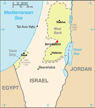
| Beschrijving | Map showing Jerusalem straddling the Green Line |
| Datum | (UTC) |
| Bron | |
| Auteur |
|
| Dit is een geretoucheerde foto, wat betekent dat de originele versie digitaal aangepast is. Aanpassingen: changed color of WB/Gaza, removed several cities and notes. Het origineel kan hier bekeken worden: Cia-is-map2.gif. Aanpassingen gedaan door Nableezy.
|
Licentie
Deze afbeelding bevindt zich in het publiek domein omdat het materiaal bevat dat oorspronkelijk afkomstig is van het CIA World Factbook.
|
 |
Oorspronkelijk uploadlogboek
This image is a derivative work of the following images:
- File:Cia-is-map2.gif licensed with PD-USGov-CIA-WF
- 2006-08-13T22:27:27Z Milan.sk 330x715 (21389 Bytes)
Uploaded with derivativeFX
Bestandsgeschiedenis
Klik op een datum/tijd om het bestand te zien zoals het destijds was.
| Datum/tijd | Miniatuur | Afmetingen | Gebruiker | Opmerking | |
|---|---|---|---|---|---|
| huidige versie | 8 dec 2011 22:26 | | 328 × 370 (35 kB) | Nableezy | upload under a different file name if you insist |
| 8 dec 2011 20:01 |  | 328 × 370 (37 kB) | Someone35 | fixed | |
| 8 dec 2011 20:00 |  | 328 × 370 (37 kB) | Someone35 | Now there's more contrast between Israel, the West bank and other countries. | |
| 4 dec 2011 03:40 |  | 328 × 370 (35 kB) | Nableezy | reposition scale, label for Mediterranean Sea and Tel Aviv | |
| 4 dec 2011 00:15 |  | 328 × 370 (35 kB) | Nableezy | cropped | |
| 3 dec 2011 07:08 |  | 328 × 715 (57 kB) | Nableezy | Removed Ashqelon, Elat, added Tel Aviv, Gaza, modified dot for Jerusalem and placement and size of word "Jerusalem" | |
| 2 dec 2011 18:06 |  | 328 × 715 (63 kB) | Nableezy | == {{int:filedesc}} == {{Information |Description=Map showing Jerusalem straddling the Green Line |Source=*File:Cia-is-map2.gif |Date=2011-12-02 16:04 (UTC) |Author=*File:Cia-is-map2.gif: CIA *derivative work: ~~~ |Permission= |other_versions= |
Bestandsgebruik
Dit bestand wordt op de volgende pagina gebruikt:
Globaal bestandsgebruik
De volgende andere wiki's gebruiken dit bestand:
- Gebruikt op en.wikipedia.org
- Gebruikt op es.wikipedia.org
- Gebruikt op lt.wiktionary.org
- Gebruikt op pnb.wikipedia.org
- Gebruikt op pt.wikipedia.org
- Gebruikt op tr.wikipedia.org
- Gebruikt op ur.wikipedia.org