Bestand:Israel districts named.png

Grootte van deze voorvertoning: 223 × 598 pixels. Andere resoluties: 89 × 240 pixels | 500 × 1.341 pixels.
Oorspronkelijk bestand (500 × 1.341 pixels, bestandsgrootte: 32 kB, MIME-type: image/png)
| Dit is een bestand van Wikimedia Commons. Onderstaande beschrijving komt van de beschrijving van het bestand daar. |
Beschrijving
| Beschrijving |
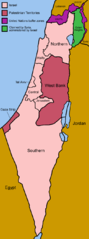
English: Map of the districts of Israel. |
| Bron | Eigen werk |
| Auteur | Made by User:Golbez |
| Andere versies | Afgeleide werken van dit bestand: Israel districts named hr.svg |
Dit bestand is gelicenseerd onder de Creative Commons-licentie Naamsvermelding-Gelijk delen 2.0 Unported
- De gebruiker mag:
- Delen – het werk kopiëren, verspreiden en doorgeven
- Remixen – afgeleide werken maken
- Onder de volgende voorwaarden:
- naamsvermelding – U moet op een gepaste manier aan naamsvermelding doen, een link naar de licentie geven, en aangeven of er wijzigingen in het werk zijn aangebracht. U mag dit op elke redelijke manier doen, maar niet zodanig dat de indruk wordt gewekt dat de licentiegever instemt met uw werk of uw gebruik van zijn werk.
- Gelijk delen – Als u het werk heeft geremixt, veranderd, of erop heeft voortgebouwd, moet u het gewijzigde materiaal verspreiden onder dezelfde licentie als het oorspronkelijke werk, of een daarmee compatibele licentie.
Bestandsgeschiedenis
Klik op een datum/tijd om het bestand te zien zoals het destijds was.
| Datum/tijd | Miniatuur | Afmetingen | Gebruiker | Opmerking | |
|---|---|---|---|---|---|
| huidige versie | 2 jul 2005 08:47 | 500 × 1.341 (32 kB) | Golbez | Map of the districts of Israel. Source: Made by User:Golbez. {{cc-by-sa-2.0}} Category:Maps of Israel\ |
Bestandsgebruik
Dit bestand wordt op de volgende pagina gebruikt:
Globaal bestandsgebruik
De volgende andere wiki's gebruiken dit bestand:
- Gebruikt op en.wikipedia.org
- Gebruikt op he.wikipedia.org
- Gebruikt op id.wikipedia.org
- Gebruikt op ms.wikipedia.org
- Gebruikt op no.wikinews.org
- Gebruikt op sh.wikipedia.org
- Gebruikt op sq.wikipedia.org
- Gebruikt op sv.wikipedia.org
- Gebruikt op yi.wikipedia.org