Bestand:Exmoor National Park UK location map.svg

Afmetingen van deze voorvertoning van het type PNG van dit SVG-bestand: 800 × 584 pixels Andere resoluties: 320 × 234 pixels | 640 × 467 pixels | 1.024 × 747 pixels | 1.280 × 934 pixels | 2.560 × 1.868 pixels | 1.425 × 1.040 pixels.
Oorspronkelijk bestand (SVG-bestand, nominaal 1.425 × 1.040 pixels, bestandsgrootte: 1,05 MB)
| Dit is een bestand van Wikimedia Commons. Onderstaande beschrijving komt van de beschrijving van het bestand daar. |
| Beschrijving |
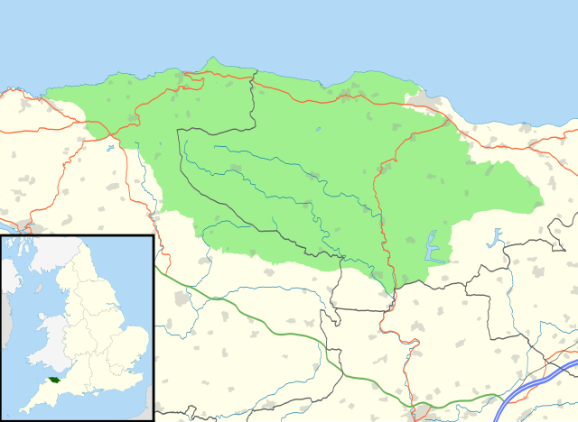
Map of Exmoor National Park, UK with the following information shown:
Equirectangular map projection on WGS 84 datum, with N/S stretched 155% Geographic limits:
|
| Datum | |
| Bron |
Office of National Statistics Geography
|
| Auteur | Nilfanion, created using Ordnance Survey data |
| Toestemming (Hergebruik van dit bestand) |
Dit bestand is gelicenseerd onder de Creative Commons-licentie Naamsvermelding-Gelijk delen 3.0 Unported Naamsvermelding: Contains Ordnance Survey data © Crown copyright and database right
|
Bestandsgeschiedenis
Klik op een datum/tijd om het bestand te zien zoals het destijds was.
| Datum/tijd | Miniatuur | Afmetingen | Gebruiker | Opmerking | |
|---|---|---|---|---|---|
| huidige versie | 29 okt 2010 23:31 | | 1.425 × 1.040 (1,05 MB) | Nilfanion | {{Information |Description=Map of Exmoor National Park, UK with the following information shown: *National Park boundary *Administrative borders *Coastline, lakes and rivers *Roads and railways *Urban areas Equirectangular map projection on |
Bestandsgebruik
Dit bestand wordt op de volgende pagina gebruikt:
Globaal bestandsgebruik
De volgende andere wiki's gebruiken dit bestand:
- Gebruikt op ar.wikipedia.org
- Gebruikt op ceb.wikipedia.org
- Gebruikt op da.wikipedia.org
- Gebruikt op de.wikipedia.org
- Gebruikt op en.wikipedia.org
- Gebruikt op eu.wikipedia.org
- Gebruikt op fa.wikipedia.org
- Gebruikt op fr.wikipedia.org
- Gebruikt op is.wikipedia.org
- Gebruikt op it.wikipedia.org
- Gebruikt op kn.wikipedia.org
- Gebruikt op nn.wikipedia.org
- Gebruikt op pnb.wikipedia.org
- Gebruikt op ru.wikipedia.org
- Gebruikt op si.wikipedia.org
- Gebruikt op tr.wikipedia.org
- Gebruikt op uz.wikipedia.org
- Gebruikt op war.wikipedia.org