Bestand:Europe 1000.jpg

Grootte van deze voorvertoning: 750 × 599 pixels. Andere resoluties: 300 × 240 pixels | 601 × 480 pixels | 961 × 768 pixels | 1.280 × 1.023 pixels | 1.932 × 1.544 pixels.
Oorspronkelijk bestand (1.932 × 1.544 pixels, bestandsgrootte: 689 kB, MIME-type: image/jpeg)
| Dit is een bestand van Wikimedia Commons. Onderstaande beschrijving komt van de beschrijving van het bestand daar. |
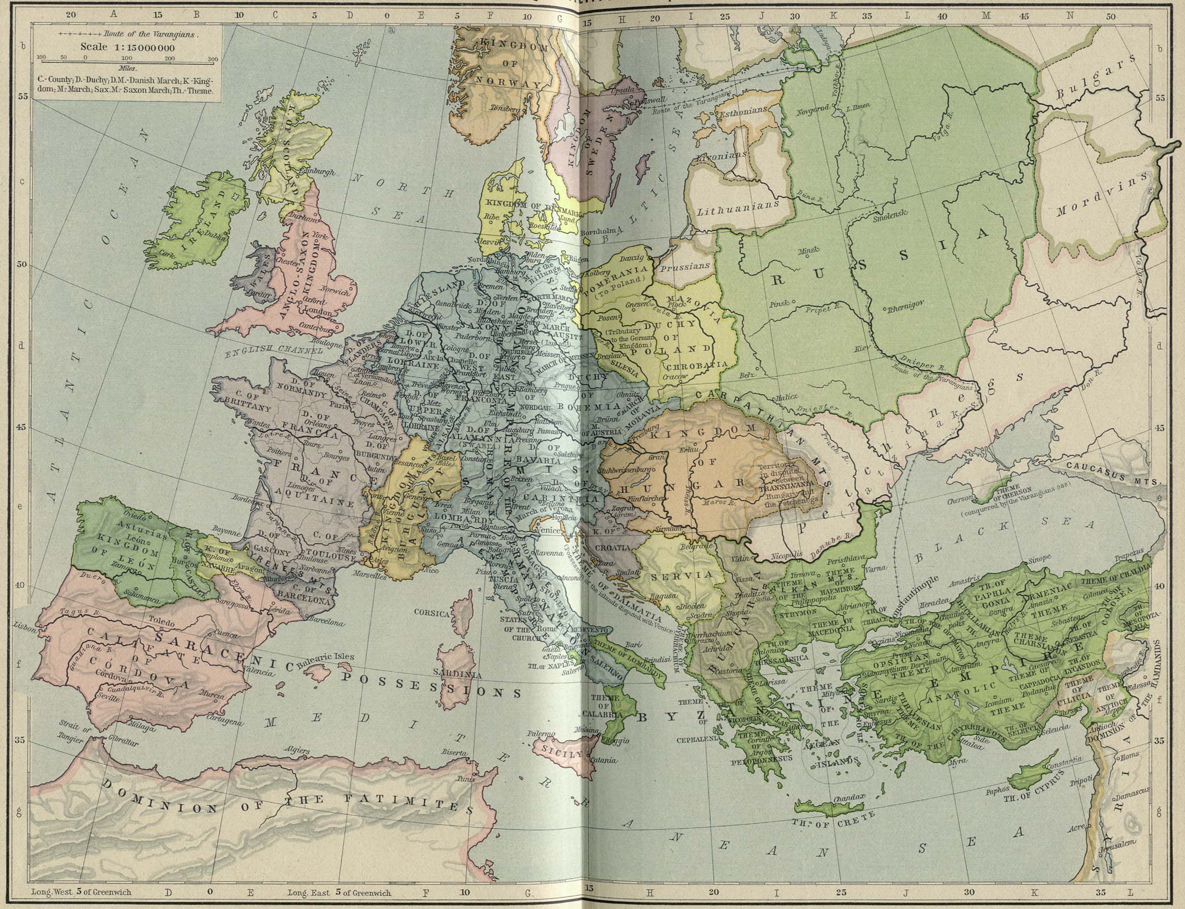
Europe in 1000
_en.png)
.png)
.jpg)
|
Dit werk bevindt zich in het publiek domein in landen en gebieden waar de auteursrechttermijn het leven van de auteur plus 70 jaar of minder is. Dit werk bevindt zich in het publiek domein in de Verenigde Staten omdat het gepubliceerd werd (of geregistreerd bij de U.S. Copyright Office) voor 1 januari 1929. | |
| Van dit bestand is vastgesteld dat er geen bekende auteursrechtaanspraken op rusten, alle aanverwante en naburige rechten daarbij inbegrepen. | |
Bestandsgeschiedenis
Klik op een datum/tijd om het bestand te zien zoals het destijds was.
| Datum/tijd | Miniatuur | Afmetingen | Gebruiker | Opmerking | |
|---|---|---|---|---|---|
| huidige versie | 8 mei 2006 12:29 | | 1.932 × 1.544 (689 kB) | Roke~commonswiki | Europe in 1000 {{Europe}} {{PD-PCL|http://www.lib.utexas.edu/maps/historical/shepherd_1911/shepherd-c-058-059.jpg}} Category: Historical maps of Europe |
Bestandsgebruik
Dit bestand wordt op de volgende pagina gebruikt:
Globaal bestandsgebruik
De volgende andere wiki's gebruiken dit bestand:
- Gebruikt op arz.wikipedia.org
- Gebruikt op av.wikipedia.org
- Gebruikt op azb.wikipedia.org
- Gebruikt op ba.wikipedia.org
- Gebruikt op bg.wikipedia.org
- Gebruikt op bn.wikipedia.org
- Gebruikt op ca.wikipedia.org
- Gebruikt op ceb.wikipedia.org
- Gebruikt op cs.wikipedia.org
- Gebruikt op de.wikipedia.org
- Gebruikt op eml.wikipedia.org
- Gebruikt op en.wikipedia.org
- Gebruikt op es.wikipedia.org
- Historia del cristianismo
- 1000
- Otón I del Sacro Imperio Romano Germánico
- Congreso de Gniezno
- Croacia Blanca
- Reino de Croacia
- Reino de Hungría (medieval)
- Usuario:Fr2002/Taller: Lista historica de las regiones y paises por PIB (PPA)
- Rutas del Camino de Santiago en Navarra
- Camino de Santiago en Navarra
- Reino de Hungría (1000-1301)
- Gebruikt op et.wikipedia.org
Globaal gebruik van dit bestand bekijken.