Bestand:ElectoralCollege1789.svg

Afmetingen van deze voorvertoning van het type PNG van dit SVG-bestand: 542 × 446 pixels Andere resoluties: 292 × 240 pixels | 583 × 480 pixels | 933 × 768 pixels | 1.245 × 1.024 pixels | 2.489 × 2.048 pixels.
Oorspronkelijk bestand (SVG-bestand, nominaal 542 × 446 pixels, bestandsgrootte: 49 kB)
| Dit is een bestand van Wikimedia Commons. Onderstaande beschrijving komt van de beschrijving van het bestand daar. |
| U.S. presidential election maps (SVG) |
| See also: National Atlas maps (png) |
|
1789 · 1792 · 1796 · 1800 · 1804 · 1808 · 1812 · 1816 · 1820 · 1824 · 1828 · 1832 · 1836 · 1840 · 1844 · 1848 · 1852 · 1856 · 1860 · 1864 · 1868 · 1872 · 1876 · 1880 · 1884 · 1888 · 1892 · 1896 · 1900 · 1904 · 1908 · 1912 · 1916 · 1920 · 1924 · 1928 · 1932 · 1936 · 1940 · 1944 · 1948 · 1952 · 1956 · 1960 · 1964 · 1968 · 1972 · 1976 · 1980 · 1984 · 1988 · 1992 · 1996 · 2000 · 2004 · 2008 · 2012 · 2016 · 2020 · 2024 |
Beschrijving
| Beschrijving |
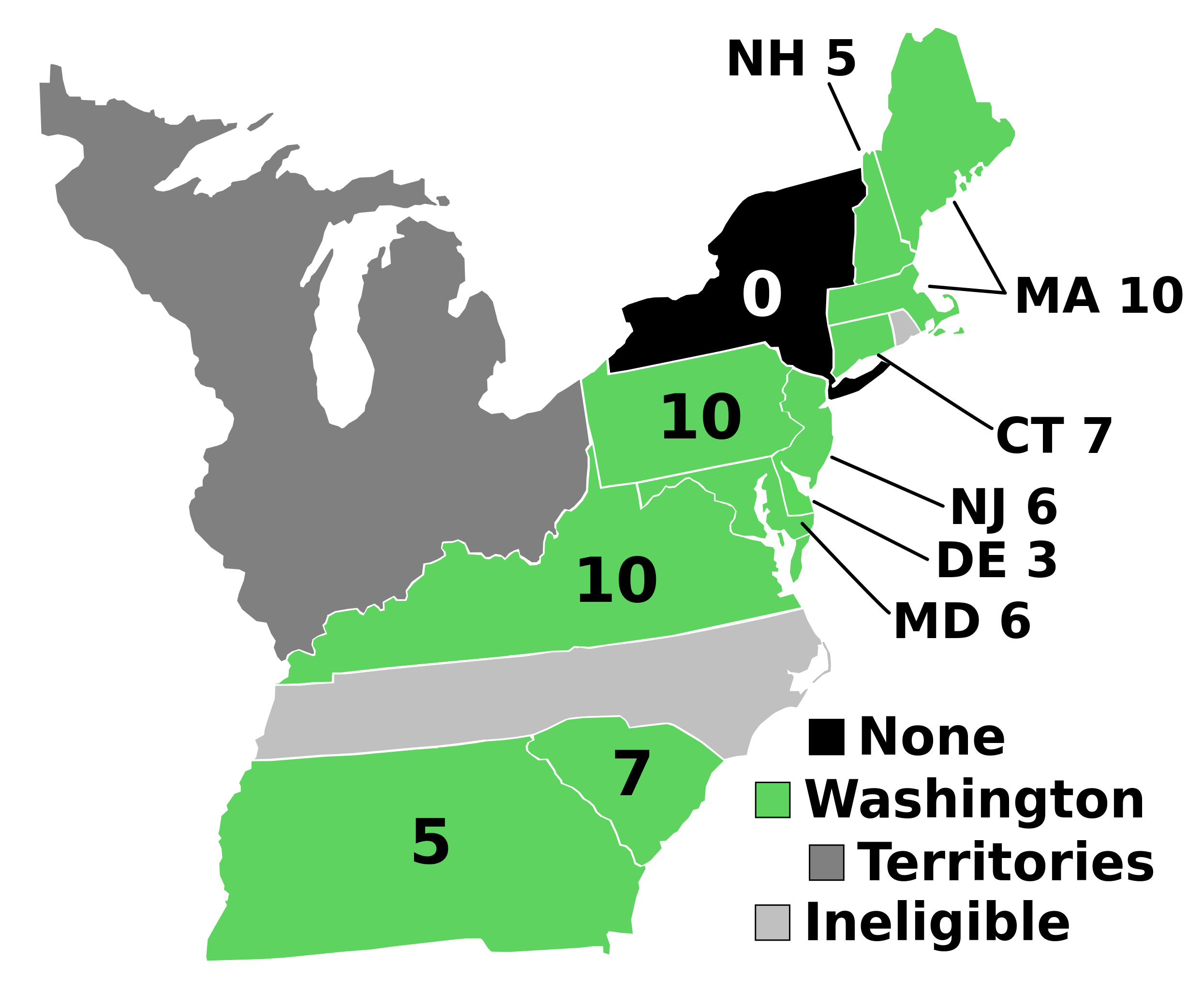
English: Electoral votes by state.
Note: North Carolina and Rhode Island had not yet ratified the Constitution so were therefore ineligible to choose electors. The New York legislature was deadlocked so therefore no electors were chosen. Vermont had been acting independently, but was still considered part of New York at the time. עברית: חלוקת האלקטורים לפי מדינה. |
| Bron | Eigen werk |
| Auteur | AndyHogan14 |
| Andere versies |
Afgeleide werken van dit bestand: |
| SVG development | W3C-validity not checked. |
Licentie
| Ik, de auteursrechthebbende van dit werk, geef dit werk vrij in het publieke domein. Dit is wereldwijd van toepassing. In sommige landen is dit wettelijk niet mogelijk; in die gevallen geldt: Ik sta iedereen toe dit werk voor eender welk doel te gebruiken, zonder enige voorwaarden, tenzij zulke voorwaarden door de wet worden voorgeschreven. |
Bestandsgeschiedenis
Klik op een datum/tijd om het bestand te zien zoals het destijds was.
| Datum/tijd | Miniatuur | Afmetingen | Gebruiker | Opmerking | |
|---|---|---|---|---|---|
| huidige versie | 2 sep 2023 19:02 | | 542 × 446 (49 kB) | Clarinetguy097 | This should fix the issue with text being cut off. |
| 2 sep 2023 18:49 |  | 542 × 446 (49 kB) | Clarinetguy097 | I'd instead argue that North Carolina and Rhode Island didn't stop being part of the US when the Constitution went into effect. | |
| 29 okt 2021 06:40 |  | 542 × 446 (38 kB) | Fluffy89502 | NC & RI were not a part of the United States | |
| 23 mei 2020 06:46 |  | 542 × 446 (40 kB) | Spellcheck | Recreated based on 1800 map for consistency Also added legend entry for ineligible states | |
| 14 nov 2016 08:46 |  | 535 × 437 (35 kB) | Wow | New York and font | |
| 22 mei 2010 06:38 |  | 535 × 437 (29 kB) | Ibagli | No DC in 1789 | |
| 31 dec 2008 21:38 |  | 535 × 437 (28 kB) | AndyHogan14 | {{Information |Description= |Source=self-made |Date= |Author= AndyHogan14 |Permission= |other_versions= }} |
Bestandsgebruik
Dit bestand wordt op de volgende pagina gebruikt:
Globaal bestandsgebruik
De volgende andere wiki's gebruiken dit bestand:
- Gebruikt op ca.wikipedia.org
- Gebruikt op cs.wikipedia.org
- Gebruikt op da.wikipedia.org
- Gebruikt op de.wikipedia.org
- Gebruikt op el.wikipedia.org
- Gebruikt op en.wikipedia.org
- 1788–89 United States presidential election
- List of United States presidential election results by state
- United States presidential election
- 1788–89 United States presidential election in Pennsylvania
- 1788–89 United States elections
- 1788–89 United States presidential election in Connecticut
- 1788–89 United States presidential election in Massachusetts
- 1788–89 United States presidential election in New Hampshire
- 1788–89 United States presidential election in New Jersey
- 1788–89 United States presidential election in South Carolina
- 1788–89 United States presidential election in Delaware
- 1788–89 United States presidential election in Georgia
- 1788–89 United States presidential election in Maryland
- 1788–89 United States presidential election in Virginia
- User:Speedicus/sandbox
- Template:State results of the 1788–89 U.S. presidential election
- Electoral history of John Adams
- Gebruikt op es.wikipedia.org
- Gebruikt op fi.wikipedia.org
- Gebruikt op fr.wikipedia.org
- Gebruikt op he.wikipedia.org
- Gebruikt op it.wikipedia.org
- Gebruikt op ja.wikipedia.org
- Gebruikt op ko.wikipedia.org
- Gebruikt op lt.wikipedia.org
- Gebruikt op lv.wikipedia.org
- Gebruikt op mk.wikipedia.org
- Gebruikt op pl.wikipedia.org
- Gebruikt op ru.wikipedia.org
- Gebruikt op simple.wikipedia.org
- Gebruikt op si.wikipedia.org
- Gebruikt op sr.wikipedia.org
- Gebruikt op sv.wikipedia.org
- Gebruikt op tr.wikipedia.org
- Gebruikt op vi.wikipedia.org
- Gebruikt op www.wikidata.org
- Gebruikt op zh.wikipedia.org