Bestand:Cretaceous seaway.png
Geen hogere resolutie beschikbaar.
Cretaceous_seaway.png (250 × 301 pixels, bestandsgrootte: 111 kB, MIME-type: image/png)
| Dit is een bestand van Wikimedia Commons. Onderstaande beschrijving komt van de beschrijving van het bestand daar. |
Beschrijving
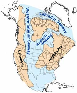
| Beschrijving | Map of North America highlighting the shallow inland seaways present during the mid-Cretaceous period. |
| Datum | |
| Bron | https://web.archive.org/web/20050115222718/climweb.cr.usgs.gov/research/fossils/ammonites.html |
| Auteur | By William A. Cobban and Kevin C. McKinney, USGS. (Image has been slightly modified by uploader to remove "CO" state designation.) |
| Andere versies | Arabic, Seaway SVG and Continent labeled SVG |
Licentie
Deze afbeelding bevindt zich in het publiek domein omdat het materiaal bevat dat oorspronkelijk afkomstig is van de United States Geological Survey, een agentschap van de United States Department of the Interior. Voor meer informatie, zie het officiële USGS-auteursrechtenbeleid
|

|
Bestand:Western Interior Seaway - 95Ma (with ancient continents).svg is een vectorversie van dit bestand. Indien niet van slechtere kwaliteit dient deze gebruikt te worden in plaats van deze rasterafbeelding.
File:Cretaceous seaway.png → File:Western Interior Seaway - 95Ma (with ancient continents).svg
Zie Help:SVG voor meer informatie. |
.svg) |
Bestandsgeschiedenis
Klik op een datum/tijd om het bestand te zien zoals het destijds was.
| Datum/tijd | Miniatuur | Afmetingen | Gebruiker | Opmerking | |
|---|---|---|---|---|---|
| huidige versie | 23 okt 2013 07:35 | | 250 × 301 (111 kB) | Kwamikagami | add names of land masses |
| 4 mrt 2005 07:00 |  | 250 × 301 (101 kB) | Hadal~commonswiki | from the USGS |
Bestandsgebruik
Dit bestand wordt op de volgende 4 pagina's gebruikt:
Globaal bestandsgebruik
De volgende andere wiki's gebruiken dit bestand:
- Gebruikt op ar.wikipedia.org
- Gebruikt op be-tarask.wikipedia.org
- Gebruikt op bg.wikipedia.org
- Gebruikt op bs.wikipedia.org
- Gebruikt op ca.wikipedia.org
- Gebruikt op cs.wikipedia.org
- Gebruikt op de.wikipedia.org
- Gebruikt op en.wikipedia.org
- Gebruikt op es.wikipedia.org
- Gebruikt op eu.wikipedia.org
- Gebruikt op fa.wikipedia.org
- Gebruikt op fr.wikipedia.org
- Gebruikt op gl.wikipedia.org
- Gebruikt op he.wikipedia.org
Globaal gebruik van dit bestand bekijken.