Bestand:Cesar Topographic 2.png
Grootte van deze voorvertoning: 250 × 598 pixels. Andere resoluties: 100 × 240 pixels | 200 × 480 pixels | 321 × 768 pixels | 1.025 × 2.453 pixels.
Oorspronkelijk bestand (1.025 × 2.453 pixels, bestandsgrootte: 5,34 MB, MIME-type: image/png)
| Dit is een bestand van Wikimedia Commons. Onderstaande beschrijving komt van de beschrijving van het bestand daar. |
Beschrijving
| Beschrijving |
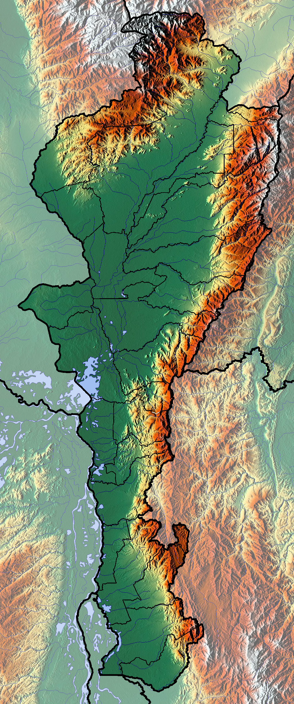
Français : Cesar dept |
| Datum | |
| Bron | Eigen werk (backgroung : http://www.maps-for-free.com) |
| Auteur | Dr Brains |
Licentie
Ik, de auteursrechthebbende van dit werk, maak het hierbij onder de volgende licenties beschikbaar:

|
Toestemming wordt verleend voor het kopiëren, verspreiden en/of wijzigen van dit document onder de voorwaarden van de GNU-licentie voor vrije documentatie, alleen versie 1.2 als gepubliceerd door de Free Software Foundation; zonder Invariant Sections, zonder Front-Cover Texts, en zonder Back-Cover Texts. Een kopie van de licentie is opgenomen in de sectie GNU-licentie voor vrije documentatie. | alleen 1.2 |
|
|
Toestemming wordt verleend voor het kopiëren, verspreiden en/of wijzigen van dit document onder de voorwaarden van de GNU-licentie voor vrije documentatie, versie 1.3 of enige latere versie als gepubliceerd door de Free Software Foundation; zonder Invariant Sections, zonder Front-Cover Texts, en zonder Back-Cover Texts. Een kopie van de licentie is opgenomen in de sectie GNU-licentie voor vrije documentatie.
|
U mag zelf één van de licenties kiezen.
Bestandsgeschiedenis
Klik op een datum/tijd om het bestand te zien zoals het destijds was.
| Datum/tijd | Miniatuur | Afmetingen | Gebruiker | Opmerking | |
|---|---|---|---|---|---|
| huidige versie | 9 jun 2012 15:29 | | 1.025 × 2.453 (5,34 MB) | Dr Brains |
Bestandsgebruik
Dit bestand wordt op de volgende 2 pagina's gebruikt:
Globaal bestandsgebruik
De volgende andere wiki's gebruiken dit bestand:
- Gebruikt op avk.wikipedia.org
- Gebruikt op bg.wikipedia.org
- Gebruikt op en.wikipedia.org
- Gebruikt op es.wikipedia.org
- Gebruikt op fa.wikipedia.org
- Gebruikt op fr.wikipedia.org
- Cesar (département colombien)
- Valledupar
- Gamarra
- Agustín Codazzi (municipalité)
- Aguachica
- San Diego (Cesar)
- San Alberto (Cesar)
- La Paz Robles
- Astrea (Cesar)
- Becerril
- Bosconia
- Chimichagua
- Chiriguaná
- Río de Oro (Cesar)
- Pueblo Bello
- Pelaya
- Pailitas
- Curumaní
- El Copey
- La Jagua de Ibirico
- El Paso (Cesar)
- González (Cesar)
- La Gloria (Colombie)
- Modèle:Géolocalisation/Cesar
- Modèle:Géolocalisation/Cesar/Documentation
- Ciénaga de Zapatosa
- Kankuamos
- Gebruikt op he.wikipedia.org
- Gebruikt op si.wikipedia.org
- Gebruikt op uz.wikipedia.org
- Gebruikt op zh.wikipedia.org