Bestand:Centre of Fordingbridge - geograph.org.uk - 1525645.jpg
Geen hogere resolutie beschikbaar.
Centre_of_Fordingbridge_-_geograph.org.uk_-_1525645.jpg (640 × 426 pixels, bestandsgrootte: 203 kB, MIME-type: image/jpeg)
| Dit is een bestand van Wikimedia Commons. Onderstaande beschrijving komt van de beschrijving van het bestand daar. |
Beschrijving
| Beschrijving |
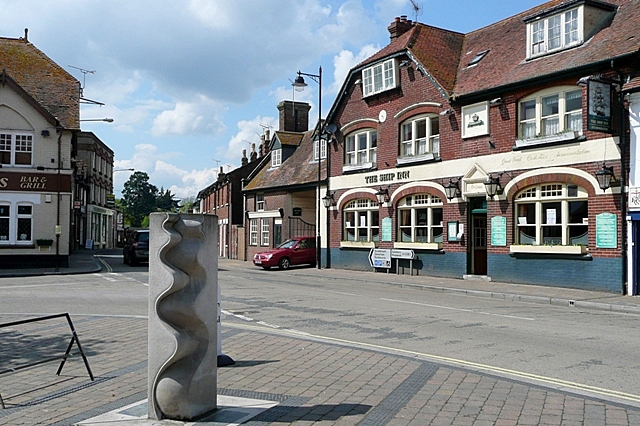
English: Centre of Fordingbridge This is the junction of Provost Street (left), Shaftesbury Street (ahead) and High Street (right) that can be regarded as the town centre. The Ship Inn probably indicates a time when the River Avon was navigable as far as the town, and the town name clearly indicates that this was the ford and later the bridge over the river. I would appreciate information about the sculpture in the foreground. The sculpture is by Paul Wilson of Salisbury. (http://wilsonsculpture.co.uk/gallery.htm) |
| Datum | |
| Bron | From geograph.org.uk |
| Auteur | Graham Horn |
| Naamsvermelding (required by the license) | Graham Horn / Centre of Fordingbridge / |
| Cameralocatie | | Deze en andere afbeeldingen in: OpenStreetMap |
|---|
_heading:292.00&language=nl)
| Objectlocatie | | Deze en andere afbeeldingen in: OpenStreetMap |
|---|
_heading:292.00&language=nl)
Licentie

|
Deze afbeelding komt uit de Geograph British Isles-collectie. Zie de pagina van deze foto op de website van Geograph voor contactinformatie van de fotograaf. Het auteursrecht van deze foto is in handen van Graham Horn en de foto is gelicenceerd voor hergebruik onder de Creative Commons Naamsvermelding-Gelijk delen 2.0 licentie.
|
Dit bestand is gelicenseerd onder de Creative Commons-licentie Naamsvermelding-Gelijk delen 2.0 Unported
Naamsvermelding: Graham Horn
- De gebruiker mag:
- Delen – het werk kopiëren, verspreiden en doorgeven
- Remixen – afgeleide werken maken
- Onder de volgende voorwaarden:
- naamsvermelding – U moet op een gepaste manier aan naamsvermelding doen, een link naar de licentie geven, en aangeven of er wijzigingen in het werk zijn aangebracht. U mag dit op elke redelijke manier doen, maar niet zodanig dat de indruk wordt gewekt dat de licentiegever instemt met uw werk of uw gebruik van zijn werk.
- Gelijk delen – Als u het werk heeft geremixt, veranderd, of erop heeft voortgebouwd, moet u het gewijzigde materiaal verspreiden onder dezelfde licentie als het oorspronkelijke werk, of een daarmee compatibele licentie.
Bestandsgeschiedenis
Klik op een datum/tijd om het bestand te zien zoals het destijds was.
| Datum/tijd | Miniatuur | Afmetingen | Gebruiker | Opmerking | |
|---|---|---|---|---|---|
| huidige versie | 3 mrt 2011 04:51 | | 640 × 426 (203 kB) | GeographBot | == {{int:filedesc}} == {{Information |description={{en|1=Centre of Fordingbridge This is the junction of Provost Street (left), Shaftesbury Street (ahead) and High Street (right) that can be regarded as the town centre. The Ship Inn probably indicates a |
Bestandsgebruik
Dit bestand wordt op de volgende pagina gebruikt:
Globaal bestandsgebruik
De volgende andere wiki's gebruiken dit bestand:
- Gebruikt op azb.wikipedia.org
- Gebruikt op ceb.wikipedia.org
- Gebruikt op cy.wikipedia.org
- Gebruikt op de.wikipedia.org
- Gebruikt op en.wikivoyage.org
- Gebruikt op es.wikipedia.org
- Gebruikt op fa.wikipedia.org
- Gebruikt op fr.wikipedia.org
- Gebruikt op ga.wikipedia.org
- Gebruikt op it.wikipedia.org
- Gebruikt op lld.wikipedia.org
- Gebruikt op ro.wikipedia.org
- Gebruikt op sv.wikipedia.org
- Gebruikt op www.wikidata.org