Bestand:Carte du Mitanni.png

Grootte van deze voorvertoning: 800 × 534 pixels. Andere resoluties: 320 × 214 pixels | 640 × 427 pixels | 1.024 × 683 pixels | 1.272 × 849 pixels.
Oorspronkelijk bestand (1.272 × 849 pixels, bestandsgrootte: 1,51 MB, MIME-type: image/png)
| Dit is een bestand van Wikimedia Commons. Onderstaande beschrijving komt van de beschrijving van het bestand daar. |
| Beschrijving |
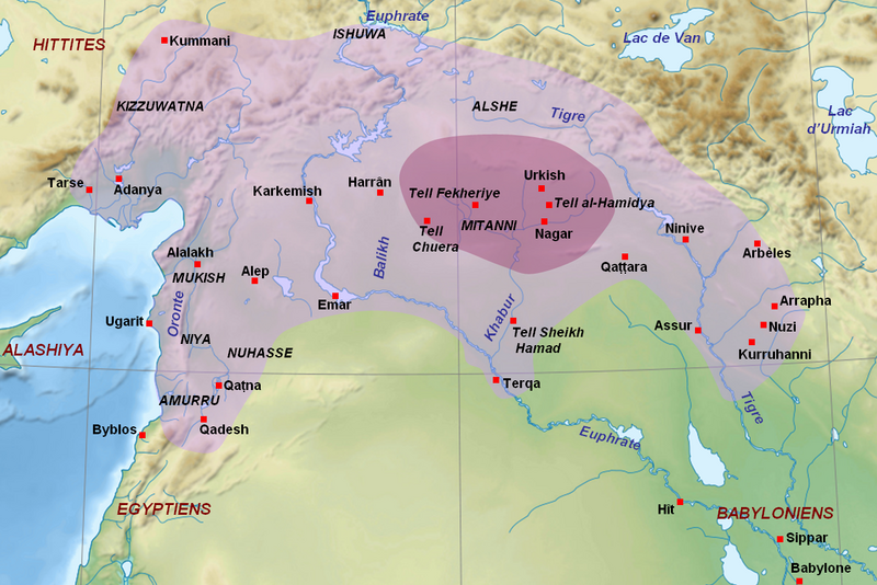
English: Map of the kingdom of Mitanni at its maximal extension, with the main cities and archaeological sites. Adapted from F. Joannès (dir.), Dictionnaire de la civilisation mésopotamienne, Paris, 2001, p. 534 (map by M. Sauvage and B. Lion), and M. Roaf, Cultural Atlas of Mesopotamia and the Ancient Near East, Oxford, 2004, p. 134 with the addition of Terqa among the vassals of Mitanni. Dark purple : the mitannian heartland ; light purple : the approximate maximal extension of the mitannian dominion.
Français : Carte du royaume du Mitanni avec ses limites approximatives à son apogée avec les principales villes et sites archéologiques. Adapté de F. Joannès (dir.), Dictionnaire de la civilisation mésopotamienne, Paris, 2001, p. 534 (carte de M. Sauvage et B. Lion), et M. Roaf, Cultural Atlas of Mesopotamia and the Ancient Near East, Oxford, 2004, p. 134, avec l'ajout de Terqa parmi les vassaux du Mitanni. Mauve foncé : le cœur du Mitanni ; mauve clair : les limites approximatives de l'extension maximale de la domination du Mitanni au début du XVe siècle av. J.-C. |
| Datum | (UTC) |
| Bron | |
| Auteur |
|
| Andere versies |
[]
|


| Dit is een geretoucheerde foto, wat betekent dat de originele versie digitaal aangepast is. Aanpassingen: Ajout des sites du Mitanni et de l'étendue du royaume. Het origineel kan hier bekeken worden: Near East topographic map-blank.svg. Aanpassingen gedaan door Zunkir.
|
Ik, de auteursrechthebbende van dit werk, maak het hierbij onder de volgende licenties beschikbaar:
Dit bestand is gelicenseerd onder de Creative Commons-licenties Naamsvermelding-Gelijk delen 3.0 Unported, 2.5 Algemeen, 2.0 Algemeen en 1.0 Algemeen.
- De gebruiker mag:
- Delen – het werk kopiëren, verspreiden en doorgeven
- Remixen – afgeleide werken maken
- Onder de volgende voorwaarden:
- naamsvermelding – U moet op een gepaste manier aan naamsvermelding doen, een link naar de licentie geven, en aangeven of er wijzigingen in het werk zijn aangebracht. U mag dit op elke redelijke manier doen, maar niet zodanig dat de indruk wordt gewekt dat de licentiegever instemt met uw werk of uw gebruik van zijn werk.
- Gelijk delen – Als u het werk heeft geremixt, veranderd, of erop heeft voortgebouwd, moet u het gewijzigde materiaal verspreiden onder dezelfde licentie als het oorspronkelijke werk, of een daarmee compatibele licentie.

|
Toestemming wordt verleend voor het kopiëren, verspreiden en/of wijzigen van dit document onder de voorwaarden van de GNU-licentie voor vrije documentatie, versie 1.2 of enige latere versie als gepubliceerd door de Free Software Foundation; zonder Invariant Sections, zonder Front-Cover Texts, en zonder Back-Cover Texts. Een kopie van de licentie is opgenomen in de sectie GNU-licentie voor vrije documentatie. |
U mag zelf één van de licenties kiezen.
Oorspronkelijk uploadlogboek
This image is a derivative work of the following images:
- File:Near_East_topographic_map-blank.svg licensed with Cc-by-sa-3.0,2.5,2.0,1.0, GFDL
- 2009-08-18T18:31:37Z Sémhur 2425x1581 (2442670 Bytes) 3 - New try
- 2009-08-17T15:39:22Z Sémhur 2425x1581 (1815374 Bytes) 2 - With the background...
- 2009-08-17T15:37:36Z Sémhur 2425x1581 (2836 Bytes) {{Information |Description={{en|1=Blank physical map of the [[:en:Near East|Near East]]}} {{fr|1=Carte physique vierge du [[:fr:Proche-Orient|Proche-Orient]].}} |Source={{own}} |Author=[[User:Sémhur|Sémhur]] |Date=2008-08-1
Uploaded with derivativeFX
Bestandsgeschiedenis
Klik op een datum/tijd om het bestand te zien zoals het destijds was.
| Datum/tijd | Miniatuur | Afmetingen | Gebruiker | Opmerking | |
|---|---|---|---|---|---|
| huidige versie | 23 sep 2010 16:00 | | 1.272 × 849 (1,51 MB) | Zunkir | Ajout de Qattara, corrections mineures. |
| 23 sep 2010 15:57 |  | 1.272 × 849 (1,51 MB) | Zunkir | Coloriage de l'extension du Mitanni, et de sa région centrale, ajout de villes et des noms des cours d'eau. | |
| 21 sep 2010 13:49 |  | 1.173 × 797 (1,42 MB) | Zunkir | {{Information |Description={{en|1=Map of the kingdom of Mitanni at its maximal extension, with the main cities and archeological sites.}} {{fr|Carte du royaume du Mitanni à son apogée avec les principales villes et sites archéologiques.}} |Source=*[[: |
Bestandsgebruik
Dit bestand wordt op de volgende pagina gebruikt:
Globaal bestandsgebruik
De volgende andere wiki's gebruiken dit bestand:
- Gebruikt op am.wikipedia.org
- Gebruikt op ar.wikipedia.org
- Gebruikt op arz.wikipedia.org
- Gebruikt op ast.wikipedia.org
- Gebruikt op ba.wikipedia.org
- Gebruikt op be-tarask.wikipedia.org
- Gebruikt op bg.wikipedia.org
- Gebruikt op bn.wikipedia.org
- Gebruikt op br.wikipedia.org
- Gebruikt op ceb.wikipedia.org
- Gebruikt op ckb.wikipedia.org
- Gebruikt op cs.wikipedia.org
- Gebruikt op de.wikipedia.org
- Gebruikt op el.wikipedia.org
- Gebruikt op en.wikipedia.org
- Gebruikt op eo.wikipedia.org
- Gebruikt op fa.wikipedia.org
- Gebruikt op fi.wikipedia.org
- Gebruikt op fr.wikipedia.org
- Gebruikt op gl.wikipedia.org
- Gebruikt op hi.wikipedia.org
- Gebruikt op id.wikipedia.org
- Gebruikt op it.wikipedia.org
- Gebruikt op ja.wikipedia.org
- Gebruikt op lt.wikipedia.org
- Gebruikt op lv.wikipedia.org
- Gebruikt op ne.wikipedia.org
- Gebruikt op pl.wikipedia.org
Globaal gebruik van dit bestand bekijken.