Bestand:California State Route 120.svg

Afmetingen van deze voorvertoning van het type PNG van dit SVG-bestand: 800 × 444 pixels Andere resoluties: 320 × 178 pixels | 640 × 356 pixels | 1.024 × 569 pixels | 1.280 × 711 pixels | 2.560 × 1.422 pixels | 1.152 × 640 pixels.
Oorspronkelijk bestand (SVG-bestand, nominaal 1.152 × 640 pixels, bestandsgrootte: 411 kB)
| Dit is een bestand van Wikimedia Commons. Onderstaande beschrijving komt van de beschrijving van het bestand daar. |
Beschrijving
| Beschrijving |
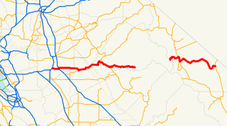
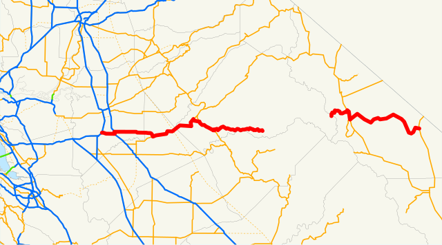
English: Route map of California State Route 120 |
| Bron | Email me if you would like a copy of the GIS data I created for the highways. |
| Auteur | NE2 (overleg · bijdragen) |
Sources: BTS North American Transportation Atlas Data archief kopie op de Wayback Machine, Caltrans State Truck Route List (XLS file), Caltrans Log of Bridges on State Highways, All Caltrans Traffic Volumes on CSHS, California State Legislature Definitions of Routes
Licentie
| Ik, de auteursrechthebbende van dit werk, geef dit werk vrij in het publieke domein. Dit is wereldwijd van toepassing. In sommige landen is dit wettelijk niet mogelijk; in die gevallen geldt: Ik sta iedereen toe dit werk voor eender welk doel te gebruiken, zonder enige voorwaarden, tenzij zulke voorwaarden door de wet worden voorgeschreven. |
Bestandsgeschiedenis
Klik op een datum/tijd om het bestand te zien zoals het destijds was.
| Datum/tijd | Miniatuur | Afmetingen | Gebruiker | Opmerking | |
|---|---|---|---|---|---|
| huidige versie | 26 apr 2021 02:34 | | 1.152 × 640 (411 kB) | Fluffy89502 | updates |
| 19 dec 2007 18:56 |  | 1.152 × 640 (374 kB) | NE2 | == Summary == This is a map of State Route 120 in California. Email me if you would like a copy of the GIS data I created for the highways. Category:California State Route 120 [[Category:Maps of state highways in California| |
Bestandsgebruik
Dit bestand wordt op de volgende pagina gebruikt:
Globaal bestandsgebruik
De volgende andere wiki's gebruiken dit bestand:
- Gebruikt op de.wikipedia.org
- Gebruikt op es.wikipedia.org
- Gebruikt op www.wikidata.org
- Gebruikt op zh-min-nan.wikipedia.org