Bestand:British empire 1886.jpg
Grootte van deze voorvertoning: 800 × 598 pixels. Andere resoluties: 320 × 239 pixels | 640 × 479 pixels | 1.024 × 766 pixels | 1.280 × 957 pixels | 1.500 × 1.122 pixels.
Oorspronkelijk bestand (1.500 × 1.122 pixels, bestandsgrootte: 625 kB, MIME-type: image/jpeg)
| Dit is een bestand van Wikimedia Commons. Onderstaande beschrijving komt van de beschrijving van het bestand daar. |
Beschrijving
| Beschrijving |
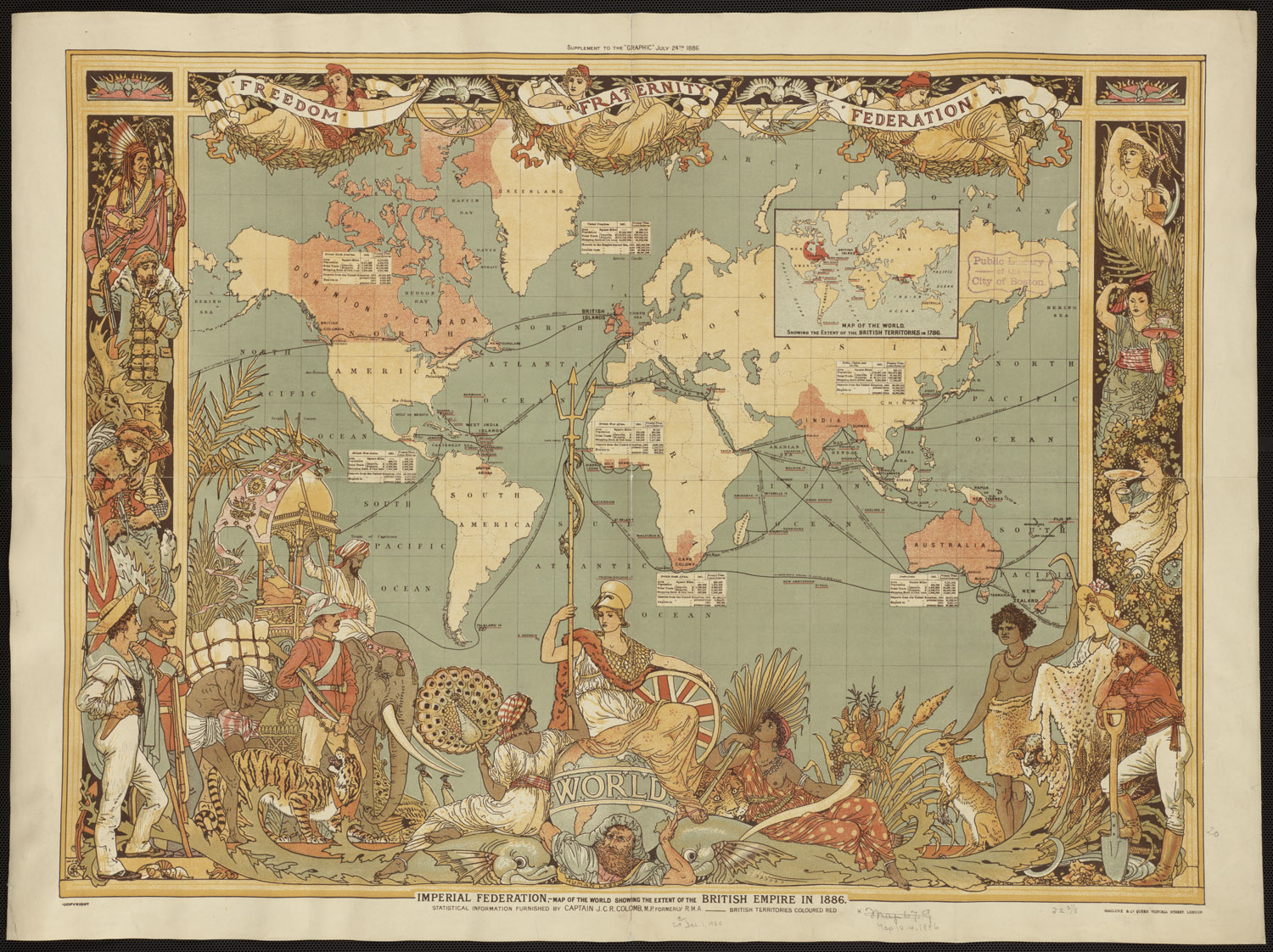
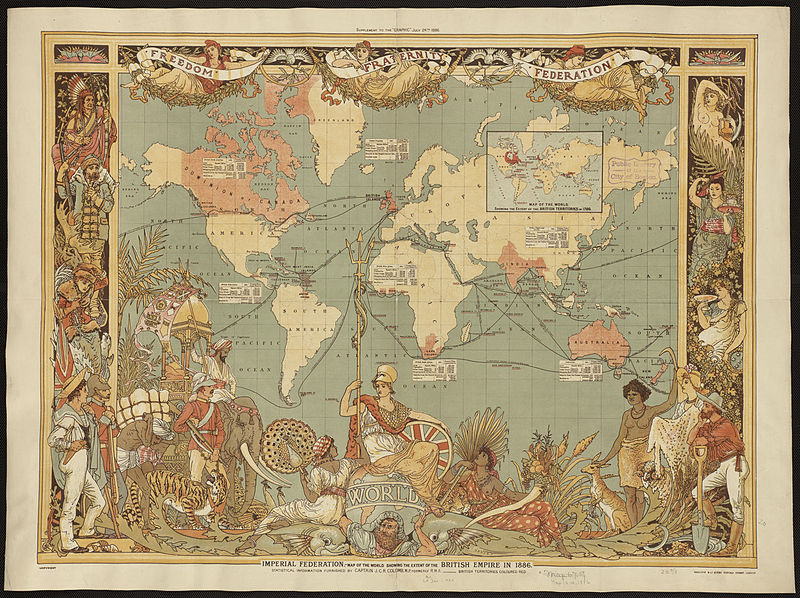
English: Map of the world showing the extent of the British Empire in 1886. British territories coloured in red. Published as a supplement for The Graphic, July 1886, as the "Imperial Federation". Statistical information furnished by Captain J.C.R. Colomb, M.P. formerly R.M.A. |
||||||||||||||||||||||||||
| Datum | |||||||||||||||||||||||||||
| Bron | https://www.flickr.com/photos/boston_public_library/4404528478/ | ||||||||||||||||||||||||||
| Auteur |
|
||||||||||||||||||||||||||
| Andere versies |
|
||||||||||||||||||||||||||


.jpg)
Licentie
|
Dit werk bevindt zich in het publiek domein in landen en gebieden waar de auteursrechttermijn het leven van de auteur plus 70 jaar of minder is. Dit werk bevindt zich in het publiek domein in de Verenigde Staten omdat het gepubliceerd werd (of geregistreerd bij de U.S. Copyright Office) voor 1 januari 1929. | |
| Van dit bestand is vastgesteld dat er geen bekende auteursrechtaanspraken op rusten, alle aanverwante en naburige rechten daarbij inbegrepen. | |
Bestandsgeschiedenis
Klik op een datum/tijd om het bestand te zien zoals het destijds was.
| Datum/tijd | Miniatuur | Afmetingen | Gebruiker | Opmerking | |
|---|---|---|---|---|---|
| huidige versie | 29 okt 2010 04:25 | | 1.500 × 1.122 (625 kB) | Nikkimaria | higher-resolution version, from [http://www.flickr.com/photos/boston_public_library/4404528478/sizes/o/in/photostream/ flickr] |
| 27 okt 2010 01:02 |  | 1.051 × 794 (1,07 MB) | Nikkimaria | {{Information |Description={{en|1=Map of the world showing the extent of the British Empire in 1886. British territories coloured in red}} |Source=The Graphic July 1886, 'Imperial Federation' |Author=en:Walter Crane (d. 1915) |Date=1886 |Permission=se |
Bestandsgebruik
Dit bestand wordt op de volgende pagina gebruikt:
Globaal bestandsgebruik
De volgende andere wiki's gebruiken dit bestand:
- Gebruikt op it.wikipedia.org
- Gebruikt op ja.wikipedia.org