Bestand:BritishWestFlorida1776.jpg

Grootte van deze voorvertoning: 800 × 415 pixels. Andere resoluties: 320 × 166 pixels | 640 × 332 pixels | 1.024 × 531 pixels | 1.752 × 908 pixels.
Oorspronkelijk bestand (1.752 × 908 pixels, bestandsgrootte: 597 kB, MIME-type: image/jpeg)
| Dit is een bestand van Wikimedia Commons. Onderstaande beschrijving komt van de beschrijving van het bestand daar. |
Beschrijving
| Beschrijving |
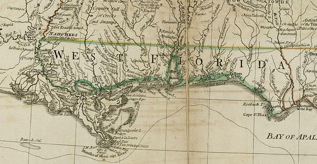
English: The source map depicts the southern British colonies in 1776, including the Carolinas, Georgia, and the Floridas, as well as labeling Indian tribal regions. This detail depicts British West Florida, roughly including the Gulf Coast between the Mississippi River and the Apalachicola River. |
| Datum | |
| Bron | From the Darlington Digital Library at the University of Pittsburgh, identifier DARMAP0298: http://images.library.pitt.edu/cgi-bin/i/image/image-idx?med=1;image_search%20btn=Go;q1=florida;rgn1=darlmaps_all;sid=9f1d2a0afbb2d02f51e12f6a87a01616;size=20;c=darlmaps;lasttype=boolean;view=entry;lastview=thumbnail;subview=detail;cc=darlmaps;entryid=x-darmap0298;viewid=DARMAP0298.TIF;start=1;resnum=7 |
| Auteur | Bernard Romans |
Licentie
|
Dit werk bevindt zich in het publiek domein in landen en gebieden waar de auteursrechttermijn het leven van de auteur plus 100 jaar of minder is. | |
| Van dit bestand is vastgesteld dat er geen bekende auteursrechtaanspraken op rusten, alle aanverwante en naburige rechten daarbij inbegrepen. | |
Bestandsgeschiedenis
Klik op een datum/tijd om het bestand te zien zoals het destijds was.
| Datum/tijd | Miniatuur | Afmetingen | Gebruiker | Opmerking | |
|---|---|---|---|---|---|
| huidige versie | 5 mei 2009 15:02 | | 1.752 × 908 (597 kB) | Magicpiano | {{Information |Description={{en|1=The source map depicts the southern British colonies in 1776, including the Carolinas, Georgia, and the Floridas, as well as labeling Indian tribal regions. This detail depicts British w:West Florida, roughly includ |
Bestandsgebruik
Dit bestand wordt op de volgende pagina gebruikt:
Globaal bestandsgebruik
De volgende andere wiki's gebruiken dit bestand:
- Gebruikt op ar.wikipedia.org
- Gebruikt op ca.wikipedia.org
- Gebruikt op en.wikipedia.org
- Gebruikt op es.wikipedia.org
- Gebruikt op fr.wikipedia.org
- Gebruikt op id.wikipedia.org
- Gebruikt op ja.wikipedia.org
- Gebruikt op ru.wikipedia.org
- Gebruikt op www.wikidata.org