Bestand:Bosnia and Hercegovina map.png

Oorspronkelijk bestand (2.302 × 2.901 pixels, bestandsgrootte: 1,5 MB, MIME-type: image/png)
| Dit is een bestand van Wikimedia Commons. Onderstaande beschrijving komt van de beschrijving van het bestand daar. |
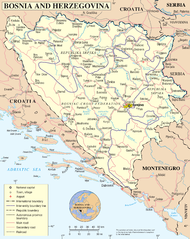
UN Bosnia and Hercegovina map
| Beschrijving | Map of Bosnia and Hercegovina | |||
| Datum | ||||
| Bron | The Cartographic Section of the United Nations (CSUN) | |||
| Auteur | Cartographer of the United Nations | |||
| Toestemming (Hergebruik van dit bestand) |
|

Bestandsgeschiedenis
Klik op een datum/tijd om het bestand te zien zoals het destijds was.
| Datum/tijd | Miniatuur | Afmetingen | Gebruiker | Opmerking | |
|---|---|---|---|---|---|
| huidige versie | 11 mei 2010 18:48 | | 2.302 × 2.901 (1,5 MB) | Ras67 | cropped |
| 23 okt 2007 03:26 |  | 2.348 × 2.948 (2,05 MB) | Jeroen | Higher reolution | |
| 10 mrt 2007 01:03 |  | 1.880 × 2.349 (1,28 MB) | Minestrone | UN Bosnia and Hercegovina map {{Information |Description=Map of Bosnia and Hercegovina |Source=The Cartographic Section of the United Nations (CSUN) |Date=2007-03-10 |Author=Cartographer of the United Nations |Permission={{Template:UN map}} and the |
Bestandsgebruik
Dit bestand wordt op de volgende 5 pagina's gebruikt:
Globaal bestandsgebruik
De volgende andere wiki's gebruiken dit bestand:
- Gebruikt op ace.wikipedia.org
- Gebruikt op als.wikipedia.org
- Gebruikt op an.wikipedia.org
- Gebruikt op bcl.wikipedia.org
- Gebruikt op ckb.wikipedia.org
- Gebruikt op cu.wikipedia.org
- Gebruikt op de.wikipedia.org
- Gebruikt op en.wikipedia.org
- Gebruikt op fa.wikipedia.org
- Gebruikt op frr.wikipedia.org
- Gebruikt op gd.wikipedia.org
- Gebruikt op hy.wikipedia.org
- Gebruikt op id.wikipedia.org
- Gebruikt op incubator.wikimedia.org
- Gebruikt op ja.wikipedia.org
- Gebruikt op jv.wikipedia.org
- Gebruikt op kg.wikipedia.org
- Gebruikt op ki.wikipedia.org
- Gebruikt op ln.wikipedia.org
- Gebruikt op my.wikipedia.org
- Gebruikt op mzn.wikipedia.org
- Gebruikt op nov.wikipedia.org
- Gebruikt op pl.wiktionary.org
- Gebruikt op ru.wikipedia.org
- Gebruikt op sl.wikipedia.org
- Gebruikt op sq.wikinews.org
- Gebruikt op uk.wikipedia.org
- Gebruikt op uk.wiktionary.org
- Gebruikt op wo.wikipedia.org