Bestand:Austria-Hungary map new.svg

Oorspronkelijk bestand (SVG-bestand, nominaal 783 × 605 pixels, bestandsgrootte: 245 kB)
| Dit is een bestand van Wikimedia Commons. Onderstaande beschrijving komt van de beschrijving van het bestand daar. |

| Beschrijving |
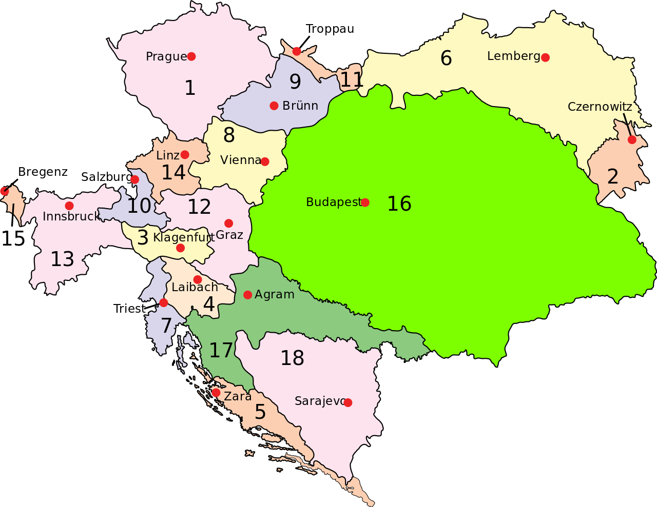
English: Austria–Hungary: Empire of Austria (Cisleithania): 1. Bohemia, 2. Bukovina, 3. Carinthia, 4. Carniola, 5. Dalmatia, 6. Galicia, 7. Küstenland, 8. Lower Austria, 9. Moravia, 10. Salzburg, 11. Silesia, 12. Styria, 13. Tyrol, 14. Upper Austria, 15. Vorarlberg; Kingdom of Hungary (Transleithania): 16. Hungary proper 17. Croatia-Slavonia; Austrian-Hungarian Condominium: 18. Bosnia and Herzegovina Deutsch: Österreich-Ungarn 1910: Cisleithanien: 1. Böhmen, 2. Bukowina, 3. Kärnten, 4. Krain, 5. Dalmatien, 6. Galizien, 7. Küstenland, 8. Österreich unter der Enns, 9. Mähren, 10. Salzburg, 11. Schlesien, 12. Steiermark, 13. Tirol, 14. Österreich ob der Enns, 15. Vorarlberg; Transleithanien: 16. Ungarn, 17. Kroatien und Slawonien; 18. Bosnien und Herzegowina Čeština: Rakousko-Uhersko: Rakouské císařství: 1. České země, 2. Bukovina, 3. Korutany, 4. Kraňsko, 5. Dalmácie, 6. Halič, 7. Rakouské přímoří, 8. Dolní Uhry, 9. Morava, 10. Salcbursko (Solnohradsko), 11. Slezsko, 12. Štýrsko, 13. Tyroly, 14. Horní Uhry, 15. Vorarlbersko; Uherské země: 16. Uhry (Horní a Dolní) 17. Chorvatsko-Slavonie; Rakousko-Uherský kondominát: 18. Bosna a Hercegovina |
||
| Datum | (UTC) | ||
| Bron | |||
| Auteur |
|
||
| Toestemming (Hergebruik van dit bestand) |
|
||
| Andere versies | Afgeleide werken van dit bestand: Austria-Hungary map hu.svgImage:Austria-Hungary map-blank.svg, for more maps derived from this template see Category:Maps of Austria-Hungary ssp. or whatlinks |
[[Category:Maps of th
|Permission= |other_versions= }}
| Dit is een geretoucheerde foto, wat betekent dat de originele versie digitaal aangepast is. Aanpassingen: Capital of Dalmatia (5) was Zara today Zadar. Het origineel kan hier bekeken worden: Austria-Hungary map.svg.
|
| |
Dit bestand is door Example op [[::Main Page| Wikimedia Commons]], in het publieke domein geplaatst. Dit is wereldwijd van toepassing. In sommige landen is dit niet mogelijk; in die gevallen geldt: |
Oorspronkelijk uploadlogboek
This image is a derivative work of the following images:
- File:Austria-Hungary_map.svg licensed with PD-user-w
Uploaded with derivativeFX
Bestandsgeschiedenis
Klik op een datum/tijd om het bestand te zien zoals het destijds was.
| Datum/tijd | Miniatuur | Afmetingen | Gebruiker | Opmerking | |
|---|---|---|---|---|---|
| huidige versie | 20 feb 2009 14:28 | | 783 × 605 (245 kB) | Ivh123 | {{Information |Description={{en| <br>'''<u>Austria–Hungary</u>''':<br>'''Empire of Austria (Cisleithania)''': 1. Bohemia, 2. Bukovina, 3. Carinthia, 4. Carniola, 5. Dalmatia, 6. Galicia, 7. Küstenland, 8. Lower Austria, 9. Moravia, 10. Salzburg, 11. Si |
Bestandsgebruik
Dit bestand wordt op de volgende pagina gebruikt:
Globaal bestandsgebruik
De volgende andere wiki's gebruiken dit bestand:
- Gebruikt op ar.wikipedia.org
- Gebruikt op azb.wikipedia.org
- Gebruikt op el.wikipedia.org
- Gebruikt op en.wikipedia.org
- Austria-Hungary
- History of Croatia
- House of Habsburg
- Yugoslav Committee
- Multinational state
- Portal:Croatia
- Croatian–Hungarian Settlement
- Wikipedia:Reference desk/Archives/Humanities/2010 November 19
- Green Cadres
- May Declaration
- National Council of Slovenes, Croats and Serbs
- Dissolution of Austria-Hungary
- User:Falcaorib
- User:JMvanDijk/Sandbox 9/Box 4
- Zagreb Resolution
- Gebruikt op eo.wikipedia.org
- Gebruikt op et.wikipedia.org
- Gebruikt op fa.wikipedia.org
- Gebruikt op hr.wikipedia.org
- Gebruikt op hu.wikipedia.org
- Gebruikt op id.wikipedia.org
- Gebruikt op it.wikipedia.org
- Gebruikt op lt.wikipedia.org
- Gebruikt op pnb.wikipedia.org
- Gebruikt op pt.wikipedia.org
- Gebruikt op ru.wikipedia.org
- Gebruikt op sh.wikipedia.org
- Gebruikt op sl.wikipedia.org
- Gebruikt op tr.wikipedia.org
- Gebruikt op uk.wikipedia.org
- Gebruikt op ur.wikipedia.org
- Gebruikt op vi.wikipedia.org