Bestand:20191121 Guyana 0062 Georgetown sRGB (49295972987).jpg

Grootte van deze voorvertoning: 800 × 533 pixels. Andere resoluties: 320 × 213 pixels | 640 × 427 pixels | 1.024 × 683 pixels | 1.280 × 853 pixels | 2.560 × 1.707 pixels | 5.472 × 3.648 pixels.
Oorspronkelijk bestand (5.472 × 3.648 pixels, bestandsgrootte: 5,17 MB, MIME-type: image/jpeg)
| Dit is een bestand van Wikimedia Commons. Onderstaande beschrijving komt van de beschrijving van het bestand daar. |
.jpg)
Beschrijving
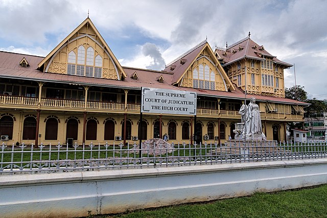
| Beschrijving | The High Court—renamed the Victoria Law Courts under the former Head of State’s rule—was completed in 1887, the Golden Jubilee year of the reign of Queen Victoria (r. 1837-1901). A marble statue of the Queen was commissioned to mark the Golden Jubilee but was not unveiled in front of the High Court [Supreme Court of Judicature] until 1894. In 1954 anti-colonial protesters dynamited the statue, blowing off the head and left hand. The statue was sent to England to be repaired. In 1970 when Guyana became a Cooperative Republic, the statue was relegated the Botanical Gardens. In 1990 the city’s mayor surprised the citizenry, and enraging some, by returning the statue to its original location. In June 2018 the statue was defaced with red paint. Georgetown, at the mouth of the Demerara River, is where the British established a town in 1781 when they captured the territory from the Dutch. The French colonized in 1782 making the town the capital named Longchamps. The Dutch reclaimed the area in 1784, renaming the town Stabroek after the president of the Dutch West India Company. The British returned and the town became Georgetown in 1812 in honor of King George III. Today Georgetown is the capital and commercial center of Guyana with the nickname ‘Garden City of the Caribbean’ for its tree-lined streets in the older parts of town. Guyana means “land of many waters” in an indigenous Amerindian language and was the original name for an entire region covering northern South America between the Orinoco (in Venezuela) and Amazon (in Brazil) Rivers. Christopher Columbus saw Guyana on his third voyage in 1498 and Sir Walter Raleigh published a fanciful description in 1595, but the first European colony was not established until 1616 with the arrival of the Dutch. They created two more colonies (in 1627 and 1752) before the British gained control in 1796 (when fighting the French who occupied the Netherlands) with the Dutch formally ceding the area in 1814. It officially became British Guiana in 1831. The economy was driven by sugar plantations worked by African slaves—more than 100,000 by 1830. Upon emancipation in 1838, agricultural production plummeted. Replacement workers were eventually found in India, with 240,000 indentured servants having been brought over by the time indentured labor was abolished in 1917. Bauxite mining beginning in 1914 created an industry that equals sugar (and rice) today (but gold is by far the leading export). Independence from the United Kingdom was achieved in 1966 with Guyana becoming an official republic within the British Commonwealth of Nations in 1970. Guyana is the only country in South America where English is the official language (but the majority of the population speaks Guyanese Creole, a version of Creole with a basis in English). |
| Datum | |
| Bron | 20191121_Guyana_0062 Georgetown sRGB |
| Auteur | Dan Lundberg |
| Cameralocatie | | Deze en andere afbeeldingen in: OpenStreetMap |
|---|
.jpg¶ms=006.810444_N_-058.165429_E_globe:Earth_type:camera_source:Flickr_&language=nl)
Licentie
Dit bestand is gelicenseerd onder de Creative Commons-licentie Naamsvermelding-Gelijk delen 2.0 Unported
- De gebruiker mag:
- Delen – het werk kopiëren, verspreiden en doorgeven
- Remixen – afgeleide werken maken
- Onder de volgende voorwaarden:
- naamsvermelding – U moet op een gepaste manier aan naamsvermelding doen, een link naar de licentie geven, en aangeven of er wijzigingen in het werk zijn aangebracht. U mag dit op elke redelijke manier doen, maar niet zodanig dat de indruk wordt gewekt dat de licentiegever instemt met uw werk of uw gebruik van zijn werk.
- Gelijk delen – Als u het werk heeft geremixt, veranderd, of erop heeft voortgebouwd, moet u het gewijzigde materiaal verspreiden onder dezelfde licentie als het oorspronkelijke werk, of een daarmee compatibele licentie.
| Deze afbeelding is oorspronkelijk op Flickr geplaatst door Dan Lundberg op https://flickr.com/photos/9508280@N07/49295972987. Dit is op 21 mei 2020 door de FlickreviewR 2-Bot beoordeeld en de licentie onder de voorwaarden van cc-by-sa-2.0 is bevestigd. |
Bestandsgeschiedenis
Klik op een datum/tijd om het bestand te zien zoals het destijds was.
| Datum/tijd | Miniatuur | Afmetingen | Gebruiker | Opmerking | |
|---|---|---|---|---|---|
| huidige versie | 21 mei 2020 21:40 | | 5.472 × 3.648 (5,17 MB) | ZiaLater | Transferred from Flickr via #flickr2commons |
Bestandsgebruik
Dit bestand wordt op de volgende pagina gebruikt:
Globaal bestandsgebruik
De volgende andere wiki's gebruiken dit bestand:
- Gebruikt op de.wikipedia.org
- Gebruikt op el.wikipedia.org
- Gebruikt op en.wikipedia.org
- Gebruikt op es.wikipedia.org
- Gebruikt op ha.wikipedia.org
- Gebruikt op id.wikipedia.org
- Gebruikt op incubator.wikimedia.org
- Gebruikt op ka.wikipedia.org
- Gebruikt op pt.wikipedia.org
.jpg)