Bestand:1997 Pacific typhoon season summary.jpg
Grootte van deze voorvertoning: 800 × 585 pixels. Andere resoluties: 320 × 234 pixels | 640 × 468 pixels | 1.024 × 749 pixels | 1.280 × 936 pixels | 2.560 × 1.871 pixels | 3.000 × 2.193 pixels.
Oorspronkelijk bestand (3.000 × 2.193 pixels, bestandsgrootte: 823 kB, MIME-type: image/jpeg)
| Dit is een bestand van Wikimedia Commons. Onderstaande beschrijving komt van de beschrijving van het bestand daar. |
| Beschrijving |
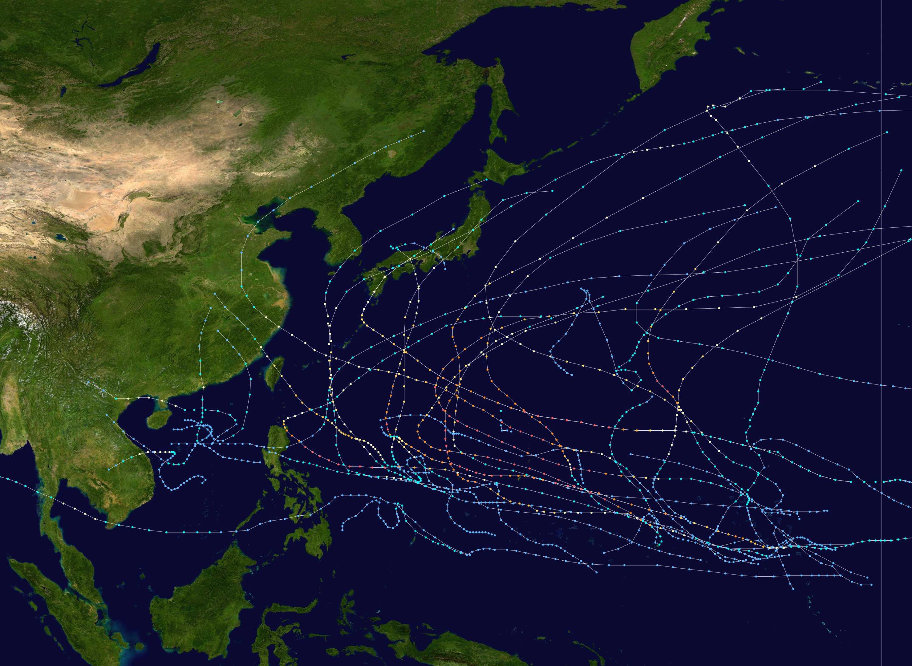
English: This map shows the tracks of all tropical cyclones in the 1997 Pacific typhoon season. The points show the location of each storm at 6-hour intervals. The colour represents the storm's maximum sustained wind speeds as classified in the Saffir-Simpson Hurricane Scale (see below), and the shape of the data points represent the type of the storm.
Tropical depression (≤38 mph, ≤62 km/h)
Tropical storm (39–73 mph, 63–118 km/h)
Category 1 (74–95 mph, 119–153 km/h)
Category 2 (96–110 mph, 154–177 km/h)
Category 3 (111–129 mph, 178–208 km/h)
Category 4 (130–156 mph, 209–251 km/h)
Category 5 (≥157 mph, ≥252 km/h)
Unknown
Storm type |
| Bron | Created using Wikipedia:WikiProject Tropical cyclones/Tracks. The background image is from NASA [1]. The tracking data is from the Joint Typhoon Warning Center's best track database |
| Auteur | Nilfanion |

|
Dit bestand kan geactualiseerd worden om nieuwe informatie te weerspiegelen. Indien je een specifieke versie van het bestand wil gebruiken zonder dat er nieuwe updates plaatsvinden, dien je die betrokken versie te uploaden als een afzonderlijk bestand. |
| Dit werk vrijgegeven in het publieke domein door de auteur, Nilfanion. Dit is wereldwijd van toepassing. In sommige landen is dit wettelijk niet mogelijk; in die gevallen geldt: Nilfanion staat iedereen toe dit werk voor eender welk doel te gebruiken, zonder enige voorwaarden, tenzij zulke voorwaarden door de wet worden voorgeschreven. |
Bestandsgeschiedenis
Klik op een datum/tijd om het bestand te zien zoals het destijds was.
| Datum/tijd | Miniatuur | Afmetingen | Gebruiker | Opmerking | |
|---|---|---|---|---|---|
| huidige versie | 11 okt 2020 01:58 | | 3.000 × 2.193 (823 kB) | Modokai | Lame |
| 16 jun 2009 15:11 |  | 1.024 × 633 (253 kB) | Cyclonebiskit | updated with larger points | |
| 3 aug 2007 00:18 |  | 3.000 × 2.193 (823 kB) | NilfaBot | {{Information |Description=This map shows the tracks of all tropical cyclones in the w:1997 Pacific typhoon season. {{PD-user|Nilfanion}} |Source= |Date= |Author= |Permission= |other_versions= }} [[Category:Pacific typhoon |
Bestandsgebruik
Dit bestand wordt op de volgende pagina gebruikt:
Globaal bestandsgebruik
De volgende andere wiki's gebruiken dit bestand:
- Gebruikt op en.wikipedia.org
- Gebruikt op pt.wikipedia.org
- Gebruikt op th.wikipedia.org
- Gebruikt op vi.wikipedia.org